
Drop Site is a reader-funded, independent news outlet. Without your support, we can’t operate. Please consider becoming a paid subscriber or making a 501©(3) tax-deductible donation today.
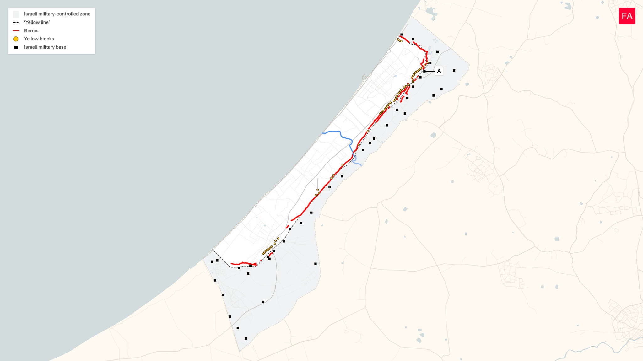
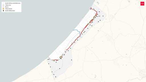
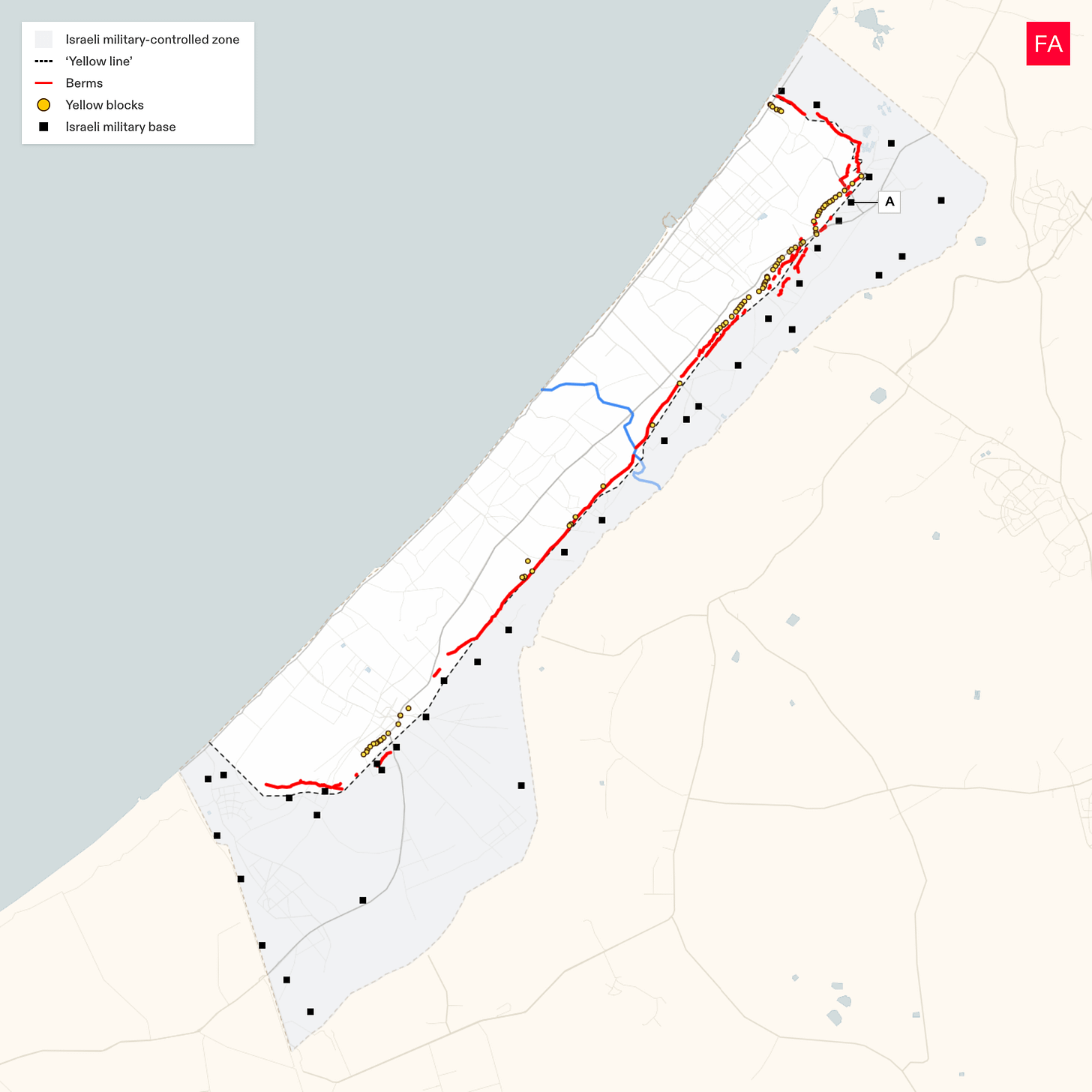
Israel has constructed 25 kilometers of earth berms roughly along the “yellow line” in Gaza and is fortifying 38 military bases on the eastern side of the territory it controls. Image by Forensic Architecture.
Israel has built more than 25 kilometers of earthen barriers inside Gaza since the “ceasefire,” according to an analysis by Forensic Architecture—physically dividing Gaza along the line of Israeli control and further corralling Palestinians into less than half of the enclave.
In the more than seven months since Hamas and Israel signed a ceasefire agreement that was supposed to end Israel’s genocidal assault in Gaza and set the stage for a phased withdrawal of Israeli troops, Israel has instead been fortifying military bases in the eastern part of the territory it controls and constructing a physical barrier walling off Palestinians from most of the Gaza Strip, according to the research, which draws on satellite imagery and other data.
As part of the October 2025 deal, Israeli troops withdrew to the “yellow line” that runs roughly parallel to Gaza’s coastline and cuts off large chunks of territory at the northern and southern ends of the enclave, giving Israel control of 53% of the Gaza Strip. Since then, they have encroached further west and now effectively control over 60% of the territory. In January, Drop Site News first published findings by Forensic Architecture that showed Israel had begun constructing berms—large, raised mounds of earth—to create a physical separation between the area it controls and the area the Palestinian population has been forced into.
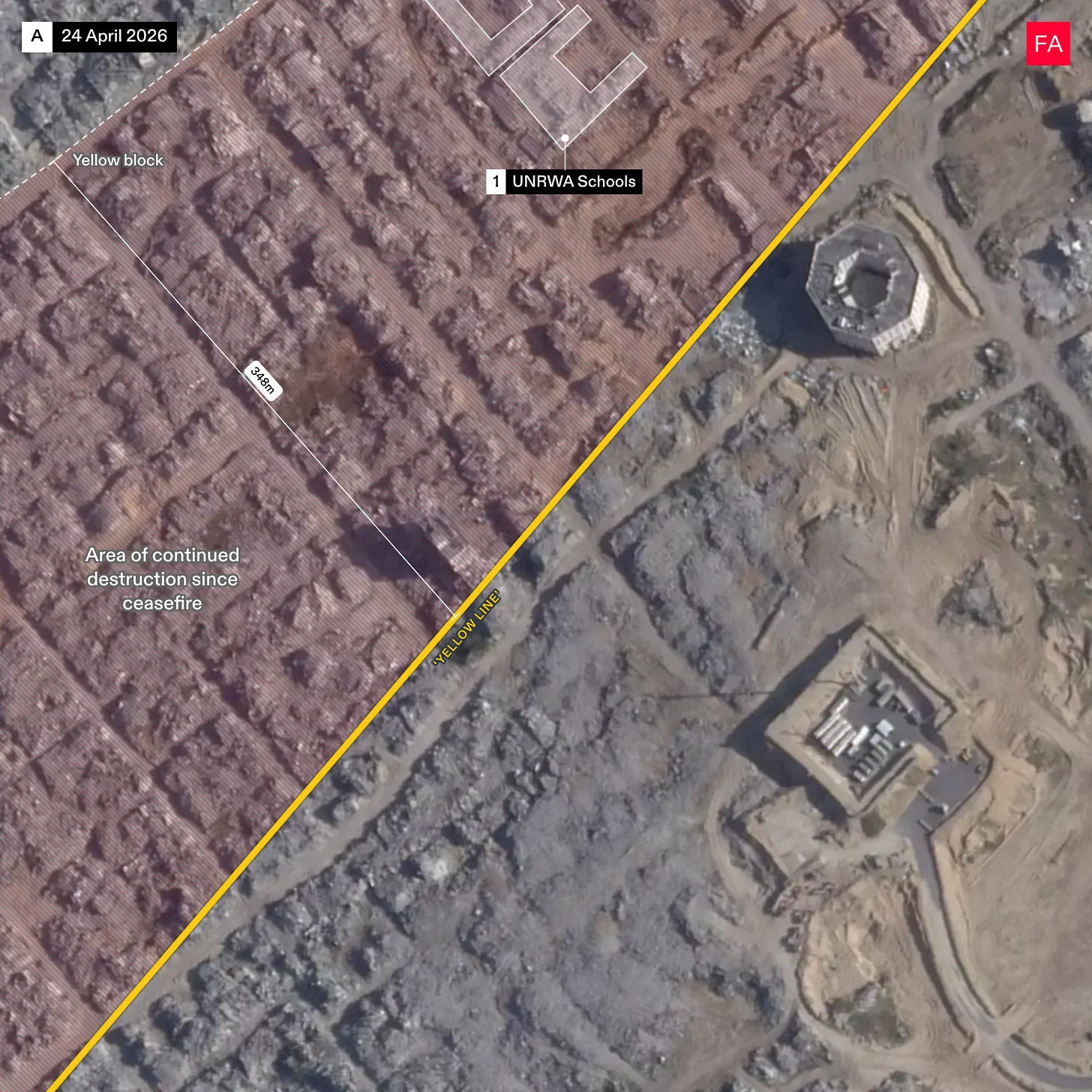
The latest findings show that the berms have been extended to create a mostly unbroken wall. Much of the berm runs west of the yellow line, going even deeper into Palestinian territory. In places like Jabaliya, the Israeli military has created a “buffer zone” along the yellow line, destroying everything in a 300 meter vicinity and creating an effective no man’s land west of the line.
“This is the danger of reading the ceasefire as an event rather than as a phase: it allows the slow violence of fortification, encroachment, and engineered uninhabitability to proceed under the cover of a word that promises its end,” Abdaljawad Omar, an assistant professor at Birzeit university in the West Bank, told Drop Site News.
“This is the whole grammar of settler-colonial space in miniature,” Omar added. “The line is never where the line is said to be. The ‘yellow line,’ like the Green Line before it, like every cartographic fiction Israel has authored, exists in order to be exceeded. It is drawn not to mark a limit but to generate the next transgression of that limit—control of 53% becomes control of 60% becomes the buffer that eats 300 meters more.”
Israel has also fortified newly constructed military bases along the yellow line, the analysis shows, by clearing the surrounding rubble, paving roads leading to the bases, adding new structures, and building even higher berms as a protective wall around the bases. There are a total of 38 Israeli military bases east of the “yellow line” that are currently operational, according to Forensic Architecture. The higher berms are flattened on top, creating a walkway for patrol and surveillance.
Video filmed by the Israeli military and published by Israeli outlet Kan News shows Israeli troops using these higher berms surrounding bases near the yellow line as a firing position to target Palestinians in the western areas where they are concentrated. While it is difficult to estimate the height of the berms from available data, the “yellow line” runs along a sandstone ridge, so all the new bases along it are not only raised with earth berms but topographically already lie high above the Palestinian area. The bases appear like elevated military forts in Gaza’s devastated landscape.
“The first thing to say about 25 kilometers of piled earth is that it is an admission dressed as an achievement,” Omar said. “A power that had promised, for two years, the total unmaking of Gaza—its ethnic cleansing, its rendering uninhabitable, the conversion of a place into a non-place—now finds itself doing the most ancient and most defensive thing a colonizer can do: building a wall and standing behind it. The berm is not the signature of victory. It is a new stalemate that Israel cannot name as such. One does not fortify against the annihilated. One fortifies against that which persists, against a presence one has failed to dissolve.”
President Donald Trump’s “Board of Peace” has unilaterally rewritten the Gaza ceasefire agreement, resistance leaders recently told Drop Site, in an effort to compel Palestinians to surrender their liberation cause and institutionalize Israeli domination over the future of the Gaza Strip. Israel and the U.S. have been trying to implement terms that Hamas never agreed to—specifically, disarming the resistance while Israeli forces continue to occupy most of Gaza and violate the ceasefire on a daily basis. Since October, more than 900 Palestinians have been killed in Gaza in Israeli airstrikes and shootings, many of them targeted close to the “yellow line.”
“What Forensic Architecture is documenting, beneath the technical vocabulary of berms and buffer zones, is the conversion of a political problem into a spatial one,” Omar said. “Israel cannot resolve the question Gaza poses—the question of a people that will not be made to disappear—so it attempts to spatialize it, to turn an irreducible political antagonism into a matter of meters, mounds, and managed distance. This is the oldest evasion of the colonial state: when you cannot answer the demand, you wall it.”
The Full Forensic Architecture Analysis
The “yellow line” is marked by 25 kilometers of new earth berms
Since our update in December 2025, Israel has continued to make the “yellow line” a physical divide, placing new yellow blocks and constructing more than 25 kilometers of berms—mounds of earth piled several meters, encircling the area in which Palestinians are concentrated.
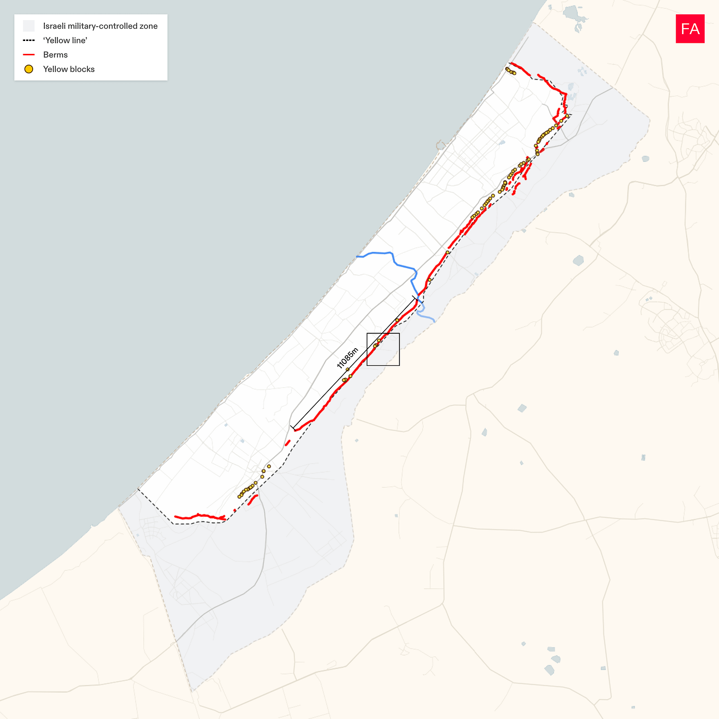
An 11-kilometer berm stretches from Wadi Gaza towards Khan Younis
This satellite image shows a section of the longest berm, which stretches 11 kilometers along the “yellow line” from Wadi Gaza towards Khan Younis. Almost all of it runs west of the line, outside of the military’s area of control.
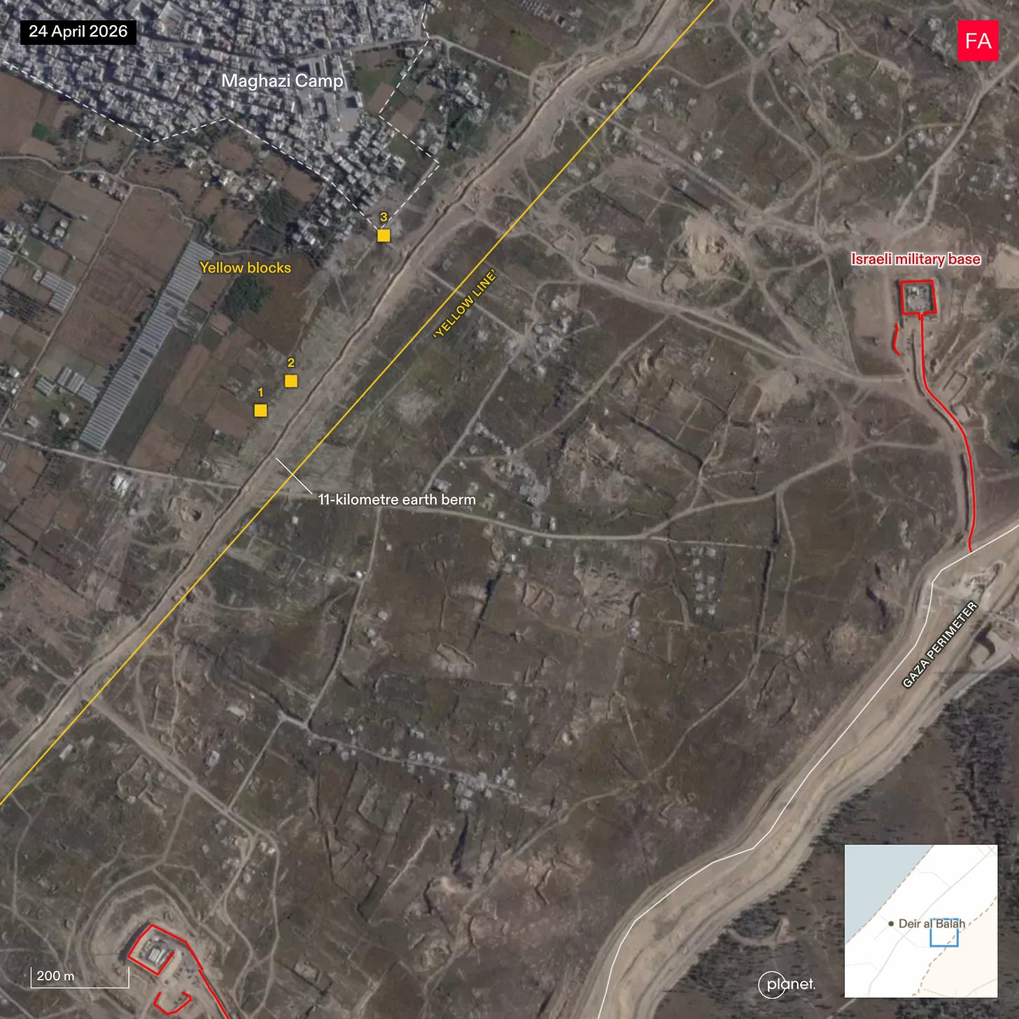
The Israeli military is consolidating and maintaining its control over the area east of the “yellow line”
These new berms further consolidate Israel’s control over the area east of the “yellow line.” It maintains its control with military bases along the line and Gaza’s perimeter.
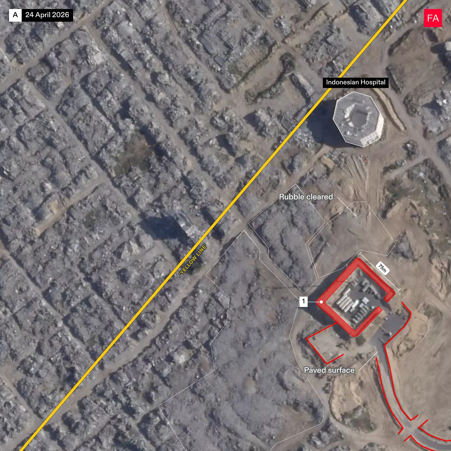
The Israeli military has expanded the infrastructure of a base in Jabaliya
In December 2025, Forensic Architecture documented the construction of a military base in Jabaliya.
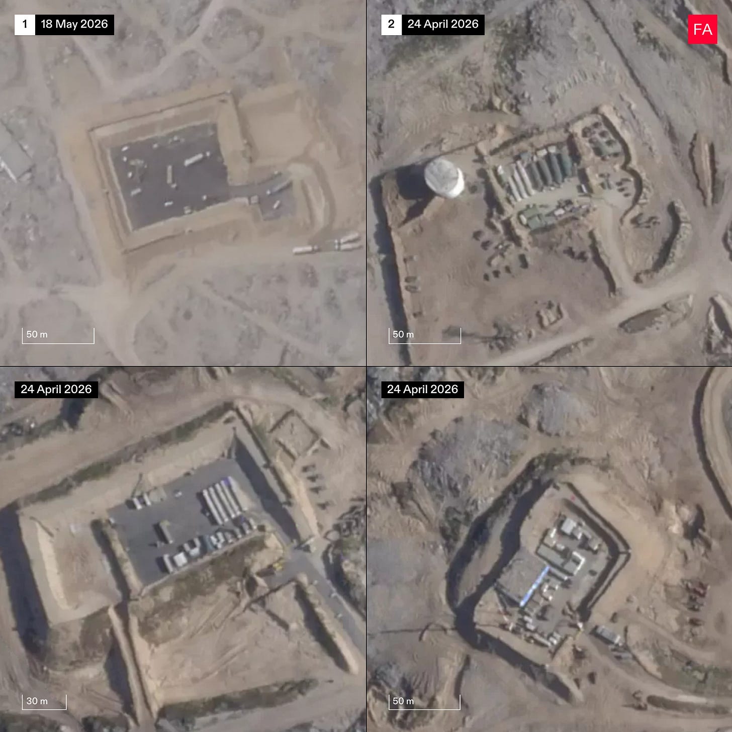
Since February 2026, Israel has fortified this base in a pattern it has repeated on bases across Gaza: it has cleared surrounding rubble, paved the base and its entry road, added structures, and constructed higher berms around the base with a patrol walkway on top.
A video filmed by the Israeli military from atop the higher berms shows it being used as a firing position by Israeli forces, who look west toward the area in which Palestinians are concentrated.
The Israeli military is “buffering” the “yellow line”
Adjacent to the base in Jabaliya, the Israeli military has destroyed a strip 300 meters beyond the “yellow line.” This destruction effectively creates a “buffer zone” between the areas under Israeli and Palestinian control.
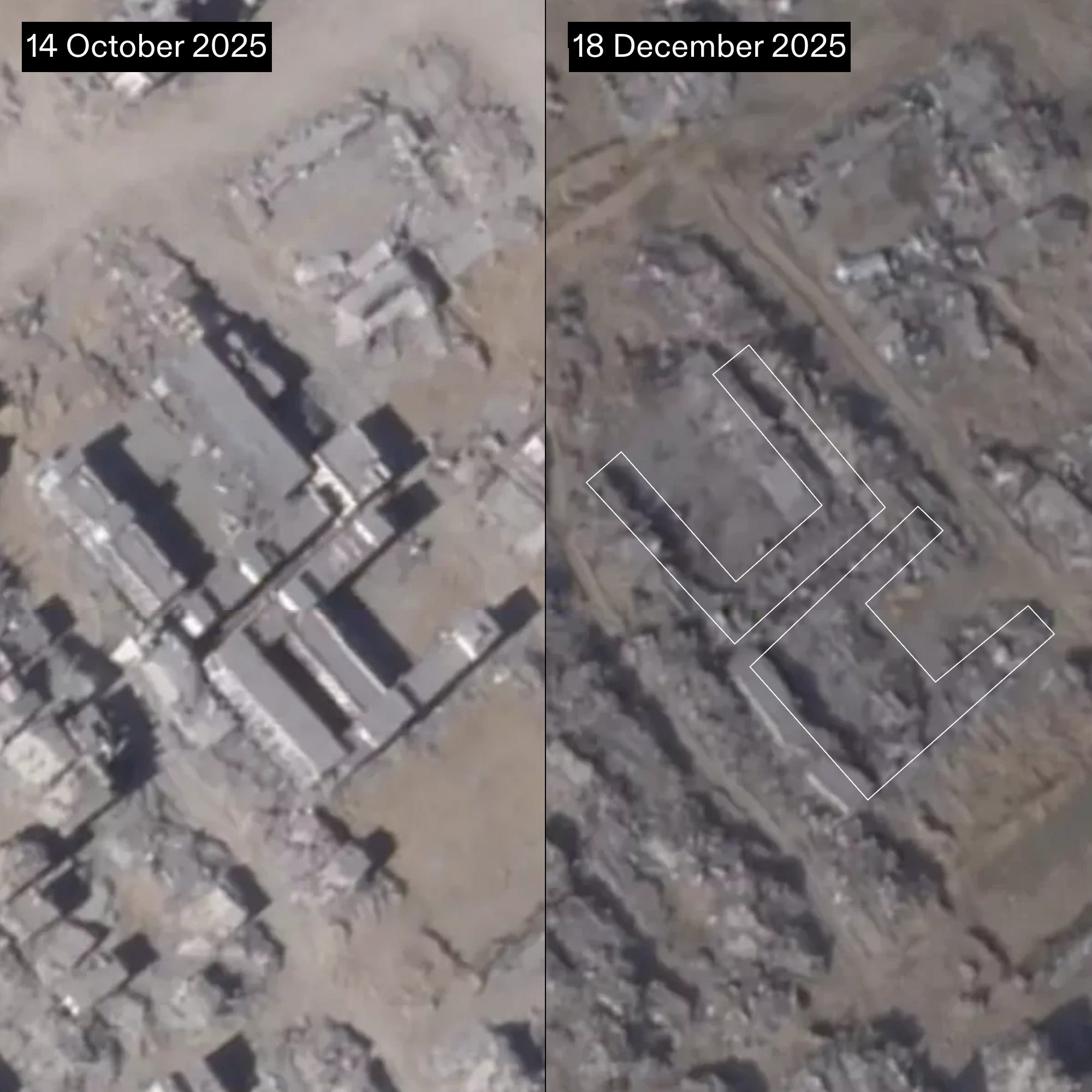
Satellite images from October 14, 2025 (left) and December 2025 (right) show the destruction of two UNRWA schools west of the “yellow line,” outside of the Israeli military’s area of control.
The Israeli military is expanding infrastructure across bases east of the “yellow line”
In recent months, the pattern of fortification we documented in Jabaliya has been repeated across military bases along the “yellow line”: satellite imagery of bases in Khan Younis, Jabaliya and Shuja’iyya shows new paving, roads, and structures, the clearing of rubble, and the construction of a second tier of berms.
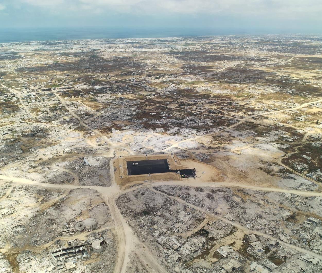
An image posted on May 8, 2026, showing a new Israeli military base at the Bani Suheila Roundabout in Khan Younis. It has a high berm perimeter, paving, and security towers.
From Drop Site News via This RSS Feed.
Video filmed by the Israeli military and published by Israeli outlet Kan News shows Israeli troops using these higher berms surrounding bases near the yellow line as a firing position to target Palestinians in the western areas where they are concentrated. While it is difficult to estimate the height of the berms from available data, the “yellow line” runs along a sandstone ridge, so all the new bases along it are not only raised with earth berms but topographically already lie high above the Palestinian area. The bases appear like elevated military forts in Gaza’s devastated landscape.
“The first thing to say about 25 kilometers of piled earth is that it is an admission dressed as an achievement,” Omar said. “A power that had promised, for two years, the total unmaking of Gaza—its ethnic cleansing, its rendering uninhabitable, the conversion of a place into a non-place—now finds itself doing the most ancient and most defensive thing a colonizer can do: building a wall and standing behind it. The berm is not the signature of victory. It is a new stalemate that Israel cannot name as such. One does not fortify against the annihilated. One fortifies against that which persists, against a presence one has failed to dissolve.”
President Donald Trump’s “Board of Peace” has unilaterally rewritten the Gaza ceasefire agreement, resistance leaders recently told Drop Site, in an effort to compel Palestinians to surrender their liberation cause and institutionalize Israeli domination over the future of the Gaza Strip. Israel and the U.S. have been trying to implement terms that Hamas never agreed to—specifically, disarming the resistance while Israeli forces continue to occupy most of Gaza and violate the ceasefire on a daily basis. Since October, more than 900 Palestinians have been killed in Gaza in Israeli airstrikes and shootings, many of them targeted close to the “yellow line.”
“What Forensic Architecture is documenting, beneath the technical vocabulary of berms and buffer zones, is the conversion of a political problem into a spatial one,” Omar said. “Israel cannot resolve the question Gaza poses—the question of a people that will not be made to disappear—so it attempts to spatialize it, to turn an irreducible political antagonism into a matter of meters, mounds, and managed distance. This is the oldest evasion of the colonial state: when you cannot answer the demand, you wall it.”