

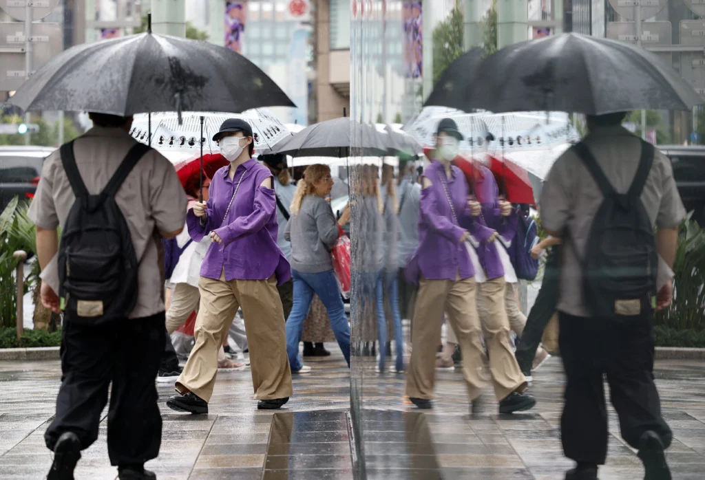
El Niño extreme weather is driving record rain in Tokyo, a powerful Pacific hurricane and shifting global risks of drought, floods and heat.
Related: Intensifying El Niño Deepens Economic Risks Across LATAM
El Niño Extreme Weather: 34 Days of Record Rain in Tokyo Signal a Growing Global Threat
El Niño extreme weather is reshaping climate risks from East Asia to the Americas. Tokyo has recorded 34 consecutive days of rainfall—the longest streak since systematic records began in 1886—while Hurricane Rachel intensified into a Category 3 storm off Mexico’s Pacific coast.
At the same time, the Atlantic basin went through September without a single hurricane for the first time in more than three decades. These events may appear contradictory, but they reflect how El Niño extreme weather redistributes rainfall, drought, heat and cyclone activity across different ocean basins rather than producing one uniform global outcome.[wmo][www3.nhk.or][pbs]
The World Meteorological Organization, or WMO, says El Niño is firmly established and is expected to intensify into a very strong event in the coming months. Forecasts indicate a near-100 percent likelihood that it will continue through February 2027, with climate impacts expected to extend well into next year.[wmo][wmo]
The implications reach far beyond weather forecasts. Persistent rain can cause flooding, landslides and urban disruption. Drought can reduce food production and water availability. Stronger or shifting tropical systems can damage coastlines, transport networks and housing. Together, these effects make El Niño extreme weather a major social, economic and humanitarian concern.
El Niño Extreme Weather Brings Record Rain to Tokyo
World Meteorological Organization El Niño update | NHK World report on Tokyo’s rainfall record | Japan Times report on Tokyo precipitation
El Niño extreme weather was visible in Tokyo after rainfall was recorded for 34 straight days, from August 27 through September 29. The Japan Meteorological Agency confirmed that the streak surpassed the previous record of 33 consecutive rainy days, set in 2019.[www3.nhk.or][japantimes.co]
The record does not mean that Tokyo experienced uninterrupted downpours for more than a month. Some days saw light rain, but the broader period included intense precipitation, a stationary autumn rain front, low-pressure systems and the impact of tropical cyclones.
By September 28, central Tokyo had received about 629 millimeters of rain during the month, making it the city’s second-highest September rainfall total on record. The figure was nearly three times the usual monthly average, according to reports citing Japan Meteorological Agency data.[japantimes.co][kuwaittimes]
The persistence of the rainfall has consequences beyond inconvenience for commuters. Saturated ground increases the risk of landslides and flash flooding, particularly in hilly terrain, river corridors and communities where drainage systems are under strain.
Tokyo and the wider Kanto region have also faced transport disruptions, difficult driving conditions and pressure on water-management infrastructure. When rain continues over many days, even well-developed cities can become vulnerable as rivers rise, soils lose their capacity to absorb water and smaller drainage networks become overloaded.
Typhoons contributed to the accumulation. Reports identified Typhoon Krovanh and Typhoon Dujuan among the weather systems that intensified precipitation across Japan. On September 21 alone, central Tokyo received 156 millimeters of rain.[ground][ua]
Japanese weather officials have said that El Niño is one part of the explanation, but it should not be treated as the sole cause. No individual weather event can be assigned automatically to one climate driver. Tokyo’s exceptional rainy spell emerged from the interaction of the autumn rain front, tropical systems, atmospheric pressure patterns and broader ocean-atmosphere changes.
El Niño affects weather by changing the distribution of heat across the tropical Pacific Ocean. Those changes influence winds, air pressure, humidity and the movement of clouds, affecting rainfall patterns far from the central Pacific.
For Japan, the resulting atmospheric configuration can help sustain rain fronts and moisture transport under certain conditions. In a warmer world, the atmosphere can also hold more water vapor, increasing the potential for heavier rainfall when storms and fronts develop.
That is why El Niño extreme weather should be understood as a risk multiplier. It does not independently create every flood, drought or cyclone, but it can alter the conditions in which those events develop and intensify.
Pacific Hurricane Activity Contrasts With a Quiet Atlantic
External links: U.S. National Hurricane Center advisory on Hurricane Rachel | PBS report on Hurricane Rachel | WMO climate outlook
While Tokyo has endured exceptional rainfall, El Niño extreme weather has also shaped risks across the eastern Pacific. Hurricane Rachel intensified into a Category 3 system off Mexico’s Pacific coast, with maximum sustained winds near 120 mph, or 195 km/h, according to the U.S. National Hurricane Center.[nhc.noaa]
Rachel was located several hundred kilometers south of the southern tip of Baja California as it moved slowly west-northwest. Although its center remained offshore, authorities warned that its outer effects could still affect coastal areas.
The National Hurricane Center said swells generated by Rachel could bring life-threatening surf and rip-current conditions to west-central Mexico and the Baja California Peninsula. Mexican authorities also warned of heavy rainfall, possible landslides, river rises and flooding in Baja California Sur, Sinaloa and Jalisco.[nhc.noaa][independent.co]
Rachel demonstrates a central fact about tropical cyclones: a storm does not need to make landfall for communities to suffer serious impacts. Outer rain bands, high surf, coastal flooding, wind and saturated soils can damage infrastructure and threaten people far from the eye of the hurricane.
This risk is especially severe in areas already affected by previous storms or prolonged rainfall. Northern Mexico and parts of the U.S. Southwest were still recovering from flooding connected to the remnants of Hurricane Polo when Rachel strengthened in the Pacific.[pbs][news4jax]
The Pacific’s activity contrasts sharply with the Atlantic, which passed through September without producing a hurricane. That had not happened in the basin since 1994, according to climate reporting cited in the original article.
The contrast does not mean that the overall climate threat has diminished. Instead, it illustrates the uneven effects of El Niño extreme weather. El Niño often increases vertical wind shear over the Atlantic—the change in wind speed or direction with altitude—which can disrupt tropical storms before they organize into hurricanes.
In the eastern Pacific, by contrast, warmer ocean conditions and different wind patterns can create an environment more favorable to tropical cyclone development or intensification. The Pacific has experienced an unusually active hurricane season, and experts have linked the regional conditions in part to El Niño.[pbs][independent.co]
The Atlantic hurricane season officially continues through November 30. A hurricane-free September is unusual, but it does not guarantee a calm October or November. One powerful late-season storm can still cause devastating impacts, especially in places with vulnerable housing, weakened infrastructure or soils already affected by unusual rainfall.
El Niño Is Strengthening in a Warmer Climate
El Niño extreme weather is tied to the natural ocean-atmosphere cycle known as the El Niño–Southern Oscillation, or ENSO. During El Niño, unusually warm surface waters develop across the central and eastern equatorial Pacific, changing atmospheric circulation and influencing weather patterns around the world.
El Niño is not new, and it is not itself caused solely by human greenhouse-gas emissions. It has occurred many times in the historical climate record. However, the present event is developing against a backdrop of unusually warm oceans and a warmer atmosphere, increasing the potential for more damaging consequences.
The WMO said the current event is fueled by exceptional ocean heat across the tropical Pacific and is expected to become very strong before reaching its peak toward the end of 2026.[wmo][reuters]
The agency has stressed that there is no conclusive evidence that climate change alone increases the frequency or strength of El Niño events. But climate change raises baseline ocean and air temperatures, giving weather systems more available heat and moisture.
That distinction matters. A naturally occurring El Niño can produce droughts, rainfall shifts and temperature anomalies. When it occurs over a warmer planet, the same circulation changes can generate more intense rainfall, longer heat waves, deeper droughts and larger impacts on communities and ecosystems.
Reuters reported that sample Pacific Ocean temperatures in the current event are already more than 2 degrees Celsius above normal and that the event is among only four classified as “very strong” in records dating to 1950.[reuters]
The consequences will not be distributed evenly. In Latin America, El Niño can deepen drought in Central America, northern parts of South America and sections of southern Chile while increasing rainfall and flood risks elsewhere.
This regional contrast requires governments to move beyond a simplified view of El Niño. The same climate pattern can drain reservoirs in one region and overflow rivers in another. Agricultural planning, emergency response and water policy must therefore be tailored to local conditions rather than based on a single regional forecast.
Food, Water and Global Inequality
The real impact of El Niño extreme weather is ultimately measured in livelihoods, food systems and public safety. Drought can reduce crop yields, raise food prices, force farming households to sell livestock and increase pressure to migrate.
Floods can destroy homes, disrupt schools, contaminate water sources and block roads that are needed to deliver food, medicine and humanitarian assistance. The people most exposed are often those with the least access to insurance, savings, formal credit, safe housing or reliable early-warning information.
Agriculture is especially sensitive because planting and harvesting depend on relatively predictable seasons. A delayed rainy season can prevent sowing, while intense rainfall during harvest can ruin crops. Extreme heat raises irrigation needs and can reduce yields for key staples.
Food security is also international. Floods or droughts in a major producing region can reduce exportable supplies and raise prices for grains, cooking oils, meat and other goods in distant markets. Climate shocks therefore move through global supply chains as well as through local communities.
The WMO and United Nations stress that El Niño provides a period of advance warning. Because the phenomenon can be forecast months ahead, governments can prepare by adjusting planting calendars, protecting water reserves, strengthening drainage, reinforcing health services and pre-positioning emergency aid.
Geopolitical Context: Climate Risk Becomes a Security Issue
El Niño extreme weather is increasingly a geopolitical issue because it can affect food production, water access, migration, trade routes and political stability across multiple regions at once.
In Central America, prolonged drought can undermine small-scale agriculture and worsen rural insecurity. In coastal Asia, prolonged rains and typhoons can disrupt global manufacturing hubs and maritime logistics. In Mexico and the Pacific, cyclones threaten tourism, fisheries, transportation and communities already facing infrastructure gaps.
The key challenge is unequal capacity. Wealthier cities may have more resources for drainage upgrades, flood defenses and early-warning systems. Low-income communities, rural farmers and small island states often face greater exposure with fewer tools to respond.
The situation in Tokyo, the intensification of Hurricane Rachel and the unusual Atlantic pattern show that El Niño extreme weather is no longer a distant forecast. The pattern is already changing the distribution of climate danger.
The WMO expects El Niño to peak late in 2026, but its consequences for rainfall, temperatures, agriculture and ocean conditions may continue throughout 2027.[wmo][wmo]
Governments now face a practical test: turn climate forecasts into action. That means maintaining flood alerts, securing water supplies, protecting food systems, preparing evacuation routes and prioritizing support for the communities most exposed to droughts, floods and extreme heat.
El Niño cannot be prevented. Its human costs can be reduced when scientific warnings are translated into public investment, regional coordination, resilient infrastructure and timely protection for people facing the greatest risk.
From teleSUR English via This RSS Feed.