


Note: This story is based on the latest available information as of 2:00 p.m. PST, July 30. Please refer to your local government, fire agency websites and social media for the most timely information regarding evacuations and road closures. For information on where to donate, check with the tribes being impacted by fires on their websites and Facebook pages.
Lyric Aquino + Brian Bull*Underscore Native News*
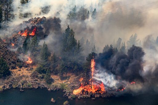
Wildfires have devastated the Pacific Northwest as Washingtonians and Oregonians watch the flames engulf their communities. In Indian Country, the fires have consumed nearly 230,000 acres. Homes have been burned, families have been displaced and the Confederated Tribes of the Colville Reservation, Confederated Tribes of Warm Springs, Confederated Tribes of the Umatilla Indian Reservation and the Confederated Tribes and Bands of the Yakama Nation are all facing evacuations.
Kaiser Canyon, Confederated Tribes of the Colville Reservation
Ripping through 129,124 acres of land in Washington as of Thursday morning, the Kaiser Canyon fire, which started on July 16 is 27 percent contained according to the latest update from the Colville Agency’s incident commander, Aaron Thompson.
The list of active evacuations hasn’t changed on the tribe’s website since Wednesday and include:
Level 3: Go Now
• Hailey Creek area: along State Hwy 155 on both sides of State Hwy 155 from Coyote Creek Campground to Haley Creek, continuing south to Hailey Creek Rd., then South to Omak Lake Rd. to Columbia River Rd. and then South to Kartar Valley Rd.
• Owhi Lake: Mill Creek area to Owhi Lake area to Bridge Creek Rd.
• Empire Creek evacuation zone: from South Nanamkin Rd. east to State Hwy 21, State Hwy 21 South to S Empire Creek Rd., East to the Ferry County Line, North to South Nanamkin Rd.
• Armstrong Meadows: east of Coyote Creek Rd, then north toward the Armstrong Meadows area
• Admin Hill: Charlie Williams Rd., east of Admin Hill. There is extreme danger in this area.
Level 2: Be Ready
• Omak Lake:-east of Omak Lake and North Omak Lake Rd. to State Hwy 155, going east on State Hwy 155 both sides of the road to Haley Creek
• Coyote Creek: Coyote Creek Rd from State Hwy 155 to Columbia River Rd.
• Moses Mountain: Haden Creek Rd. in the Moses Mountain area up to the northern border of the Colville Reservation
• Central Peak: east of Moses Mountain, east to the county line, south to the Central Peak area, west to the area of Mill Creek, then north to the East Moses Mountain area
• West Fork: northwest along Gold Lake Rd. continuing to West Fork and State Hwy 21, then South on State Hwy 21 to South Nanamkin Creek Rd., west on
South Nanamkin Creek Rd. to the intersection of Central Peak Rd. and the Ferry County line, then north along the Ferry County line to Gold Lake Rd.
• Cache Creek South-: From Cache Creek Rd. South to the West side of State Hwy 21, to the east of the Nespelem Agency campus
• Nespelem area: north of Nespelem Agency, including the town of Nespelem and School Loop Rd., and both sides of State Highway 155 up to Coyote Creek Rd.
In a briefing Thursday, Operations Sections Chief Keith Kelley said he’s satisfied with the fire management taking place.
“I think things are looking really good [we’re] really trying to prepare this to the best of our ability to be able to sustain these strong winds that are going to come Saturday,” he said.
, Kelley said his team lit a preventative fire Wednesday evening to reduce fuel near Summit Lake, an area he said wasn’t prioritized because resources were needed elsewhere.
“So we put fire on the ground to remove some of the fuel that’s between the leading edge of the fire and our dozer line,” he said. “We closed that gap to remove that so we can continue to really take out any kind of punch that might have as these conditions we have here continue to get drier and hotter and as we prepare for the strong gusty winds that are coming on Saturday.”
Additionally, another fire was lit near Central Peak Road and Cache Creek with the goal to stop the fire from moving North.
“By doing that it’ll help us really keep fire from spreading to the North and East and really help us protect the communities and the residents that live along the highway 121 corridor,” Kelley said.
Kelley noted that there are 1,091 personnel on the ground with shifts circling at all hours.
“We like to do a handoff and then get folks right back there on the day shift so we don’t have any space where this active fire is that we don’t have resources on,” he said.
The Confederated Tribes of the Colville Reservation are accepting donations to their Cedar Fund for people affected by the fires.
Current Road Closures
• Kartar Rd remains CLOSED.
• State Hwy 155 is CLOSED from Monument south to Park City Loop Rd.
• Cache Creek Rd remains CLOSED from Nespelem to State Hwy 21.
Bench Fire, Confederated Tribes of Warm Springs
According to the Oregon State Marshal fire incident team, the Bench Fire burning across the Warm Springs Reservation in north central Oregon has now exceeded 64,000 acres. 802 personnel have tackled its southwestern edge to prevent it from spreading into residential and business areas to the north and east, as well as Madras. At last check, six homes and five outbuildings were destroyed, though a Level 3 (Go Now!) warning was downgraded to Level 2 (Be Ready) for several areas:
- Agency
- Campus
- Museum
- Community Center
- Elmer Quinn
- West Hills
- Tenino Apartments
- Elliot Heights
- Greeley Heights
- Tenino East
Level 3 (Get Out!) designations are still in effect for:
- Dry Hollow
- Tenino West
- Upper Seekseequa
- Lower Seekseequa
Evacuation centers are located at the Old School Cafeteria at 1150 Warm Springs Street, and St. Patrick’s Church at 341 Southwest J Street in Madras.
In a release issued late Wednesday afternoon, the Confederated Tribes of Warm Springs said it would be open for normal business hours on Thursday.
“I wish we, the tribal government itself, would have been a little more prepared because this fire did move pretty quick,” said Edward Henderson, Secretary-Treasurer and CEO of the Confederated Tribes of Warm Springs. “In fact, some of the firefighters are saying that the behavior of the fire was unique. It would literally turn 90 degrees in the wind.”
Henderson said the evening winds are what drove up the fire last Saturday.

Underscore Native News senior reporter Brian Bull (top) talks to Edward Henderson, Secretary/Treasurer and CEO of the Confederated Tribes of Warm Springs (bottom) on July 29, 2026, about the latest developments with the Bench Fire burning across the reservation. (Brian Bull/Underscore Native News)
“I thought it was over with, really to tell you the truth,” he said. “But I looked at it and saw – my amazement on Saturday when I looked – and it was this big plume, and it was moving this way, so consequently, it put the government back on its feet a little bit, as fast as it moved.”
The forecast shows moderately high temperatures reaching 87 degrees on Thursday, and highs reaching 96 on Friday. With no rain expected anytime soon, and with wind gusts continuing through the weekend, the potential for the Bench Fire to expand is high.
Henderson said the outpouring of support for affected Warm Springs residents has been “great.” At last check, the tribe’s donation site had raised nearly $103,000 of its $250, 000 goal.
For supplies, Henderson said short-term needs include water and food, with long-term items including clothes, bedding, and personal hygiene items for those whose homes were destroyed.
“Some of the members don’t have cars, some of the members don’t have money enough to buy gas to even get to the next town, let alone just leave,” said Henderson on the challenges many Warm Springs residents face. He also expressed concern about the moderate to unhealthy levels of smoke particulates in the air, urging people to get air filters for elders.
“My concern is that we have the fire to the north burning, the Grasshopper Fire,” he added. “We talked about that and what’s the odds of it coming on tribal lands here. “We’re saddened that that’s burning, but then for it to sweep down from the north, that would be a bad thing.”
A similar occurrence happened last weekend, when the Beachcomb and Bench Fires merged, increasing the acreage burned. Henderson said he’s very concerned for the devastation to areas containing First Foods, namely berries and roots, which will not be gathered this year due to the wildfires.
The other damage could come to the tribe’s timber interests. Speaking as the tribe’s fiscal officer he said, “We’ll lose revenue from any harvest that we could do.”
Thursday morning also saw the CTWS public utility branch issue a water conservation orderfor the entire water system south of Shitike Creek, adding that water tanks are at “critical levels.”
A public information officer for the Bench Fire told Underscore Native News that a community meeting for tribal members only will be held Thursday at 6:00 p.m. at the Warm Springs Community Center at 2200 Hollywood Boulevard on the Warm Springs Reservation.
Hagen Fire, Confederated Tribes of the Umatilla Indian Reservation
As of late Thursday morning, the Hagen Fire burning on the Umatilla Reservation about 23 miles of Pendleton is at over 33,500 acres and 3 percent contained. Two other fires in the area of the Umatilla Reservation —the Horse Ridge and Paradise Fires— are at 838 and 765 acres respectively.
According to the Facebook page for the three fires, nearly 1100 personnel from Walla Walla, Athen and Elgin are on the scene. The Oregon Air National Guard has four heavy helicopters backing up efforts, with more than 64,000 gallons of water dropped on the Hagen Fire Wednesday. Incident reports say a “successful burnout operation” was also carried out Wednesday to secure the fire’s west side along Rattlesnake Ridge. Some more prescribed burns will take place Thursday.
The Paradise Fire is 10 miles southeast of Walla Walla, and shows minimal growth. The fire is entirely within the municipal watershed for the city, and fire suppression is being carried out carefully to not endanger the watershed.
The Horse Ridge Fire near Meacham is 95 percent contained, with fire crews continuing mop-up operations until it’s out and no longer a threat.
The Umatilla County Sheriff’s Office says local residents must remain “extremely vigilant and proactively monitor surrounding fire activity.” Evacuation levels have been elevated in areas of Umatilla County, Union County and the Confederated Tribes of the Umatilla Indian Reservation, and people are urged to see the latest advisories on Umatilla County’s website and follow the Umatilla County Sheriff’s Office on Facebook for evacuation updates.
Travis Baker, operations chief for Northwest Team 7, said in a Thursday morning briefing that the Hagen Fire has stayed south of the north fork of the Umatilla River, and has been kept in place with water-scooping aircraft while ground crews continue to dig in containment lines.
Concerns are focused on the weekend weather. An update posted on the Hagen Fire’s Inciweb summary for Thursday says that winds will become the primary threat. “A stronger, dry cold front will move through the northwest, accelerating westerly winds over the fire areas. The forecast right now is confidently depicting wind gust potential between 30 and 35 mph throughout the day on Saturday.” Combined with dry fuels and highs in the mid 80s, expansion of the Hagen Fire is possible.
The Inciweb summary says that road closures begin at the northwest corner of Forest Service boundary in Township 3 N, Range 36 E, Section 28. Closure then follows the Forest Boundary north and east to the intersection with Highway 204. Closure continues along Highway 204 south to intersection with Forest Boundary in Section 1. Closure continues east and south along Forest Boundary to the intersection of Walla Walla Ranger District and La Grande Ranger District. Follow the boundary between the two Districts to FSR 31. The closure continues FSR 31 to Forest Boundary, then follows Forest Boundary north to Section 28. Also included in the closure is FSR 31 at its intersection with the Forest Boundary to its junction with FSR 32, and FSR 32 and FSR 50 in its entirety, Woodward Campground and Woodland Campground.
The Oregon Red Cross has an evacuation shelterset up at Sunridge Middle School on 700 Southwest Runnion Ave. in Pendleton. It can also take in small housepets including cats, dogs, and turtles, but not large ones such as horses or livestock. Red Cross officials say pets can’t be dropped off on their own, and owners must be registered and responsible for their pet’s daily care including feeding, walking and cleanup.
White Swan/Ransier Fires – Confederated Tribes and Bands of the Yakama Nation
The Yakama Nation reported in a press release that as of Thursday the Signal Peak Fire has grown to over 3,000 acres resulting in “substantial impacts to community infrastructure and Tribal assets.”
The fire destroyed seven occupied homes, four abandoned residential structures and four operational buildings. Additionally, several fleet vehicles, equipment units and inventory assets sustained significant damage or were lost entirely.
According to the Wildfire Enterprise Geospatial Portal website the fire is 50 percent contained.
“Damage assessments remain ongoing, and officials are continuing to evaluate the full scope of losses associated with the incident,” the release read.
The Ransier Fire expanded to nearly 1,300 acres and caused “significant damage to residential, community and cultural properties.” As of now, seven homes, two abandoned residences, the local post office, a church and a short house have been lost to the fire which is reported to be 50 percent contained. Emergency personnel are continuing to assess the full extent of the damage while working to protect remaining structures and supporting community members.
Currently, fire suppression operations are underway with a combined deployment of 25 engines and water tenders, one doze, one hand crew and four overhead personnel.
Displaced residents and evacuees can head to the following locations for resources:
- Harrah Elementary School (Red Cross Location)
- Yakama Nation Tribal Schools (Red Cross Location)
- Toppenish Longhouse (Open for breakfast and lunch through Jul 31)
- Wapato Longhouse (Open for meals, not shelter)
The Yakama Nation is accepting donations at its drop-off center located at the Yakama Nation Sprung Structure, 150 Robbin Rd., Toppenish WA, daily from 10:00 a.m. to 6:00 p.m…
Donation items must be new. Needed items include: blankets, pots and pans, pillows, all sizes of clothing, undergarments, diapers, baby bottles, baby formula, hygiene kits, first aid kits, portable power banks, charging cables, grocery cards, gas cards, flashlights, batteries, dog bowls, leashes, collars, toys and totes.
Contact Elizabeth Sanchey at 509-945-2939 or whiteswanfire@yakama.cim for donation inquiries, current needs or to schedule a pick-up appointment.
The post Firefighters work to contain wildfires raging through Native land appeared first on ICT.
From ICT via This RSS Feed.