


Note: This report is based on the most recent updates as of 1:53 p.m. PST, July 27. Please refer to local government and fire agency websites and social media for the most timely information regarding evacuations.
Brian BullUnderscore Native News
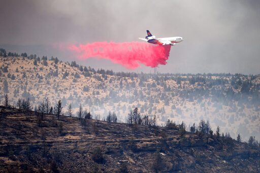
Firefighters, pilots and equipment operators are mobilized across much of Indian Country in Washington and Oregon, to rein in wildfires that have endangered many tribal communities.
In a statement issued Monday by the Confederated Tribes of Warm Springs, Tribal Chairman Dennis White III said, “I want to assure our Tribal membership that our highest priority is the safety and well-being of our Nation. We remain committed to protecting lives, property, and our lands. We will continue working closely with emergency responders, Incident Command, and or local, state, and federal partners as we navigate this crisis together.”
“I ask everyone to continue following evacuation orders, remain vigilant, and keep our firefighters, first responders, emergency personnel, and all those affected in your prayers. Together we will support one another as we move through this emergency.”
Colville Reservation and the Kaiser Canyon Fire
At 124,251 acres, the Kaiser Canyon Fire is the largest active fire in Washington. It started on July 16 after a lightning strike hit the Colville Reservation in the Nespelem Area. 884 personnel are on-site, with 15 percent of the fire contained.
“Crews will continue direct attack where possible and use indirect tactics when terrain or conditions are hazardous,” according to Inciweb’s latest summary on the fire. “Firefighting resources will be strategically reassigned to protect structures and at-risk assets along the northern and eastern fire perimeters, including the Kartar, Nespelem, Owhi Lake, and Keller areas.”
Gusts of up to 20 miles per hour in areas with lots of dry and dead brush have fueled the Kaiser Canyon fire’s growth, though winds are expected to ease on Wednesday.
Areas that are in Level 3 evacuation status “GO NOW” are:
- Along Highway 155 on both sides of the highway from Coyote Creek Campground to Haley Creek, continuing south to Hailey Creek Road, then South to Omak Lake Road to Columbia River Road and then South to Kartar Valley Road;
- the area of Kartar Road and Coyote Creek Road; the Jackson Ranch area, north to Mill Creek area, to Owhi Lake area, to Buffalo Lake Road, back to the Nespelem Agency, Owhi Lake area to Buffalo Lake Road back to the Nespelem Agency to Nespelem;
- and from South Nanamkin Road east to Hwy 21, Hwy 21 South to S Empire Creek Rd, East to the Ferry County Line, North to South Nanamkin Road.
For road closures:
- Kartar Road remains closed due to active fire danger; Buffalo Lake Road South from the Nespelem Agency is closed to Reynold Resort;
- State Route 155 is CLOSED from Monument south to Park City Loop Road;
- Cache Creek Road remains CLOSED from Nespelem to State Highway 21;
- SR 155 is closed to Park City Loop Road due to fire and dangerous trees in the area.
Travelers are advised to check PerimeterMap.com for the latest road closure information.
The Cedar Fund of the Colville Indian Reservationhas created a fund to help people and families affected by wildfires on the reservation.
Confederated Tribes of Warm Springs and Bench Fire
Over the weekend, the Beachcomb and Bench Fires on the Warm Springs reservation in north-central Oregon merged, and officials now call it the Bench Fire. At 40,296 acres, it remains completely uncontained. Inciwebsays there’s potential for “extreme fire behavior, wind driven runs and long-range spotting.”
As winds increased in velocity, officials confirmed on Monday morningthat the Bench Fire destroyed six homes and five outbuildings (agricultural and non-residential outhouses). As assessments of structural losses continue, they say the fire has created three potential fronts threatening the Warm Springs community.
On Sunday, fire crews finished a bulldozer and hand-dug line along the M-100 Road and completed another dozer line and controlled burn along Palmer Lane to help protect buildings. According to Inciweb Monday, 281 personnel are engaged in direct suppression work at Campbell and Willow Creeks, and “conduct point protection around Warm Springs and other threatened communities while securing areas,” where the Bench Fire crossed roads and the Deschutes River.
High temps will range between 89 and 94 degrees Fahrenheit Monday, with low humidity, with some gusts up to 15 miles per hour in the afternoon.
The Bench Fire began on July 23 and its cause remains under investigation.
“GO” evacuation notices remain in effect for the Warm Springs Agency District, including:
- All of Greeley Heights
- Tenino Apartments
- Trailer Courts
- West Hill
- Elmer Quinn Park
- The Campus Area
- And any residents along Shitike Creek.
“GO” evacuation notices also remain in place for:
- Pelton Park
- Pelton Dam
- Dry Hollow
- Lake Simtustus
Residents should follow local emergency notifications and evacuation instructions.
Travelers are encouraged to monitor roadway status and conditions, including US Highway 26, via the Oregon Department of Transportation’s TripCheck website.
Relief supply sites have been set up in the Portland and Gresham areas, at Oregon State Rep. Ricki Ruiz’ district office at 135 NW 1st Street, Suite 1 in Gresham (between 10 a.m. – 2 p.m. PST); Bison Coffee House, 3941 NE Cully Blvd. in Portland; and Parcera Vintage at 1428 NE Broadway, in Portland.
Desired donations include water and no-cook foods; blankets, basic medical supplies, pet supplies, childcare supplies, hotel donations and gift cards, fans, air filters, and personal hygiene kits. People are encouraged to text or call these sites to schedule dropoffs or pick-ups.
Confederated Tribes of Umatilla Indian Reservation – Hagen Fire
Last Wednesday, the Confederated Tribes of Umatilla Indian Reservation’s Board of Trustees declared a state of emergency for the reservation until conditions improve. At 26,879 acres, the Hagen Fire continues to burn nine miles southwest of Tollgate. Inciweb reportedthat firefighters dropped 50,000 gallons of water Sunday to slow its spread. According to Inciweb, the north perimeter of the fire at Bingham Road is holding and with mopping up operations continuing. There is no containment yet, with the Hagen Fire expanding to the east and south, and some more moderate growth to the west.
The Oregon State Fire Marshal says there are four incident management teams, firefighters, and other resources working on “six conflagrations” or large fires in the area. This includes the Horse Ridge and Paradise Fires. Altogether there are 946 personnel committed to the area.
“These women and men are working around the clock to protect numerous communities threatened by wildfire,” stated the OSFM on their Instagram account.
Air quality is poor and a public health emergency also remains in effect. The Umatilla Tribes’ emergency management plan will have tribal officials meeting daily with the Oregon Department of Human Services, American Red Cross, and the emergency management and public health departments of Umatilla County.
An emergency shelter with clean air has been set up at Sunridge Middle School at 700 SW Runnion Avenue in Pendleton.
The latest on evacuation levels and other wildfire information can be found on the county website.
Yakama Nation, Signal Peak and White Swan Fires
As of 9:00 a.m. Monday, Yakima County Emergency Management has lowered evacuation levels back to Level 2 “Be Ready” near White Swan. A Level 3 “Leave Now!” notice was issued Sunday afternoon at 2:00 p.m., after a new fire was spotted near Ransier and Wesley Roads.
As of 2:55 p.m. Monday, the White Swan (Ransier) Fire was estimated to be at 901 acres and 52 percent contained.
According to Watch Duty, another fire, Signal Peak, remains uncontained and has burned 3,074 acres. The fire started around 3:30 p.m. last Friday.
Heavy brush, grass, and timber have fueled the fires. Shelters have been established at the Yakama Nation Tribal School, the Harrah Elementary School, the Wapato First Baptist Church, and the Wapato and Toppenish longhouses. The causes for both fires remain under investigation.
“These fires have affected families, homes, cultural resources, and community facilities across the Yakima nation,” wrote Christopher Wallahee, Tribal Council Executive Secretary for the Confederated Tribes and Bands of the Yakama Nation. “We recognize the tremendous efforts of emergency personnel, volunteers, tribal programs, and community members who continue to support one another during this challenging time.”
Wallahee encouraged everyone to remain alert, follow evacuation guidance, monitor tribal emergency updates, and check on relatives, elders and neighbors who might need assistance.
“Our thoughts are with all those impacted by the signal peak fire and Ramseier fire. Together, our community remained strong, resilient, and committed to helping one another through recovery and rebuilding.”
The post Wildfires blaze through Pacific Northwest tribal lands appeared first on ICT.
From ICT via This RSS Feed.