

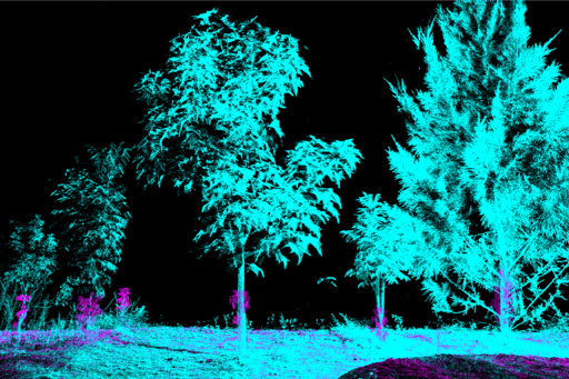
Forests are natural carbon sinks. But as reforestation of degraded land is becoming a global climate solution, a persistent question lingers: How do we know how much carbon a forest is actually storing? Researchers say ground-based laser scanning, or LiDAR, could improve the efficiency of measuring the outcomes of reforestation. And a recent paper published in Ecological Solutions and Evidence found that LiDAR scanning in Australia offered an improvement over other methods of carbon estimation. LiDAR instruments emit thousands of tiny laser pulses to create complex and intricate 3D maps of a forest’ structure, allowing researchers to more accurately estimate how much carbon is contained in its trees. Co-author of the paper Alexander W. Cheesman, a senior research fellow at James Cook University, North Queensland, Australia, calls the technology “transformative.” “Traditional field surveys heavily relied on manually measuring the height and diameter of a relatively small number of trees. But laser scanning captures the whole forest in 360 degrees, recording every stem, every branch and the shape of the canopy,” Cheesman told Mongabay during a virtual interview over Google Meet. In Australia, the Full Carbon Accounting Model (FullCAM) is the government’s main tool to track carbon stored in soil and roots (belowground carbon) and vegetation (aboveground carbon). It is used for national greenhouse gas reporting to the United Nations and to assess carbon credit within the country, through the government’s Australian Carbon Credit Unit (ACCU) Scheme. Rather than directly measuring carbon, FullCAM simulates the movement of carbon through ecosystems by…This article was originally published on Mongabay
From Conservation news via This RSS Feed.