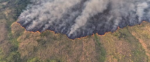
Satellite alerts suggest deforestation in the Brazilian Amazon is continuing to fall, putting the country on pace for one of its lowest forest-clearing years in more than a decade. The decline comes as climate scientists warn that a likely strong El Niño could still bring a difficult fire season, even if clear-cutting remains low. New data from Brazil’s National Institute for Space Research, or INPE, show that its DETER alert system detected 370 square kilometers (143 square miles) of deforestation in the Amazon in May. That was down from 960 square kilometers in May 2025, a decline of about 61%. Data from INPE’s DETER and Imazon’s SAD detection systems showing deforestation in the Legal Amazon (“Amazonia”) from Aug 1 to May 31 since 2008. Image by Mongabay Data from INPE’s DETER and Imazon’s SAD detection systems showing deforestation in the Legal Amazon (“Amazonia”). Image by Mongabay May is an important month in the Amazon deforestation calendar. It often marks the transition toward the drier season, when forest clearing and burning tend to increase across parts of the southern and eastern Amazon. Monthly satellite figures can vary because of cloud cover, timing and the way alerts are processed, but the latest data extend a longer downward trend. Over the past 12 months, DETER registered 3,182 square kilometers of deforestation in the Brazilian Amazon. That compares with 4,633 square kilometers during the same period a year earlier. The total is the lowest for any 12-month period in the DETER record dating…This article was originally published on Mongabay
From Conservation news via This RSS Feed.
Not if they elect a Bolsonaro again