

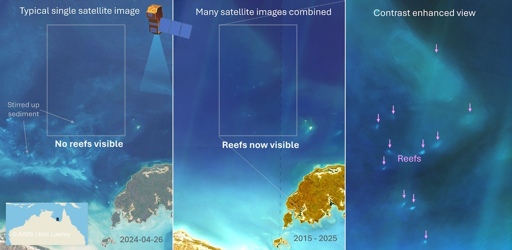
Scientists have layered hundreds of satellite images to reveal more than 1,000 previously uncharted coral reefs in the turbid waters of northern Australia. The number is comparable to the Great Barrier Reef, though many reefs are smaller in size, researchers say. The reefs of northern Australia, while probably known to locals, had previously largely remained under surveyed. Project leader Eric Lawrey from the Australian Institute of Marine Science (AIMS) wondered why, as he explored satellite imagery of the coastline and noticed shapes that looked like reefs. The possible reefs were located in deep, turbid and sediment-rich waters, making them hard to discern in a single image. “If you look at any one satellite image, the water just looks like turquoise paint and you can’t really see reefs,” Lawrey said in a media release. So Lawrey had the idea to layer 200 satellite images of each area, taken at different times. In this composite image, “all the swirly patterns of the moving water move around and average out while the reefs are constant,” he said. Using this new composite imagery technique, the team from AIMS in partnership with the University of Queensland (UQ) mapped the reefs from Houtman Abrolhos in Western Australia all the way through to western Cape York in Queensland. The resulting work defined the location of more than 3,600 coral reefs and 2,900 rocky reefs, or reefs formed by geological processes. These reefs likely support an array of marine life. The newly mapped reefs of northern and northwestern…This article was originally published on Mongabay
From Conservation news via This RSS Feed.