

Drop Site is a reader-funded, independent news outlet. Without your support, we can’t operate. Please consider becoming a paid subscriber or making a 501©(3) tax-deductible donation today.
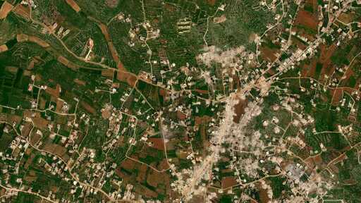
The village of Aitaroun in southern Lebanon on April 16, 2026. Credit: OnGeo Intelligence.
BEIRUT, Lebanon—Ali Murad knew his hometown of Aitaroun in southern Lebanon near the border with Israel was under heavy assault by the Israeli military. Since it was impossible for anyone to go there to check on his family house, he turned to satellite imagery to try and find out.
Once home to some 20,000 people, Aitaroun has been completely displaced by the Israeli military, which has re-invaded and occupied swathes of southern Lebanon with tanks and troops over the past seven weeks. Now based in Sweden, Murad, 39, could only watch from afar as his hometown—where he spent his childhood—was taken over. Videos began circulating online of the Israeli military engaged in widespread destruction and systematic demolition of homes and civilian infrastructure in the area. Aitaroun, whose name is of Aramaic-Syriac origin and means “the high dwellings,” lies within the Bint Jbeil district, where some of the heaviest Israeli assaults have taken place.
The Israeli military has continued the demolition campaign in places like Aitaroun despite a ceasefire announced earlier this month. In the first week of the ceasefire, Israel committed nearly 500 ceasefire violations, according to Lebanon’s National Council for Scientific Research, a government-affiliated body, including 142 cases of demolition.
Murad, who inherited the home in Aitaroun from his grandparents, last spent time in Aitaroun during a visit back to Lebanon last year. “It’s a simple village home surrounded by a small garden,” he told Drop Site News, “it has great emotional value to me.”
“It’s what keeps me connected to Lebanon,” he added.
But now there is no prospect for people to return to their homes. The Israeli military published a map last week, showing a newly established “Yellow Line” line running 5-10 km deep along the border into Lebanese territory where its troops were deployed and would remain. The map named more than 50 villages in the south, including Aitaroun, to which residents were ordered not to return. Israeli Defense Minister Israel Katz last month declared they would “accelerate the destruction of Lebanese homes in border villages…in accordance with the Beit Hanoun and Rafah model in Gaza,” referring to two areas of Gaza that have been completely razed to the ground.
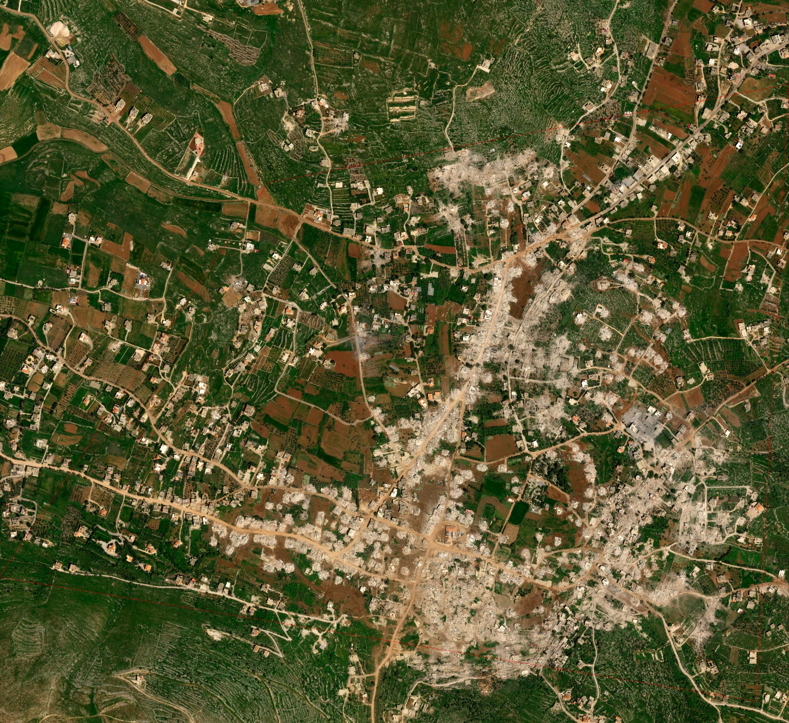
The only way Murad could check on his home was to obtain a satellite image of the village to try and discern whether it was still standing. He decided to purchase an image from OnGeo Intelligence, a U.S.-based company that provides satellite imagery for a fee. He had first turned to OnGeo during the earlier phase of the war that stretched from 2023 to 2024 to see the status of his hometown.
“I identified the geographic location I wanted and paid around $350 for a single image,” Murad said. He eventually pooled money together with other displaced residents and ordered 10 images covering the entire village. Once the results arrived, he forwarded the PDF reports to a WhatsApp group made up of displaced residents with some 1,200 members. “People want to see their homes, and this is the only way today,” he said.
The images were devastating.
“My house was burned down in the last war, but it held on. In this war, it was completely destroyed, nothing is left,” he said, adding that the ancient olive trees on his property had disappeared without a trace. “I didn’t spend much on my family’s home, but what it means to me is the smell of the past and the memories of my childhood. It’s an old house we restored to preserve its soul.”
On most streets in the village, not a single structure could be seen standing in the images, which Murad shared with Drop Site. The destruction was near total.
“The whole village is gone,” Murad said, his voice barely above a whisper.
Over 1.1 million people in Lebanon—about one fifth of the population—have been displaced since Israel escalated its assault on March 2, according to the United Nations. More than 2,300 have been killed. The vast majority have been displaced from the south and the southern suburbs of Beirut. The Israeli military has issued repeated sweeping displacement orders for all residents south of the Zahrani River to displace to the north.
For many residents unable to return to their homes in the south, satellite imagery has become the only way they can find out the state of their homes. Some scour the internet for images publicly available online, while others, like Murad, pool resources with their former neighbors to purchase images of specific locations.
OnGeo says the granularity of its images sets it apart from other services. “We provide current satellite imagery from civilian satellites in the highest resolution available. All imagery is undistorted and includes the exact date and time of capture,” the company said in an emailed response to questions from Drop Site. “The images provided do not exceed 1 square kilometer, so our product faithfully reproduces terrain details.”
Typically used by governments and energy companies for investment projects and disaster response, OnGeo has taken on a different role in Lebanon, becoming a resource for displaced residents from frontline towns and villages who can no longer check on their homes in person.
OnGeo said it has observed an increase in demand for satellite imagery of Lebanon during both the earlier and current phases of the war. “One indication has been the higher number of refunds for unfulfilled orders related to that area,” the company said. “This can occur when the requested images include military sites or other restricted locations, which are subject to the operators’ internal policies and regulatory limitations.”
Murad says he received a similar response to some of his requests. While he was able to buy seven images covering the entire village, three to four other requests were denied by OnGeo with no explanation other than: “The service provider declined to provide the image.”
A young man from Yahmar al-Shaqif, a village just north of the Litani river, told Drop Site he also recently resorted to pooling money with a group of friends to purchase three satellite images from OnGeo. “I went to my village a week before the ceasefire decision, but I won’t be able to go back now,” he said. He spoke to Drop Site on condition of anonymity for security reasons.
The images have yet to arrive, a feeling he compared to waiting for exam results. “You don’t know if you passed or failed,” he said. “Our hearts race, and anxiety takes over.”
However, resorting to satellite imagery platforms like OnGeo is not without its privacy risks, according to Abed Kataya, Program Director at SMEX, a digital rights organization focused on the West Asia and North Africa regions.
“We don’t know if [OnGeo] shares this information with third parties, or how the purpose behind requesting these images might be interpreted, and what conclusions could be drawn from them,” Kataya told Drop Site. “Purchasing satellite images requires a high degree of caution, especially in the context of war and conflict,” he said.
Part of the concerns extend beyond the images themselves to the technical data involved in the ordering process. Using a mobile phone or computer to pinpoint a specific geographic location may allow for the tracking of the user’s IP address, Katya said.
“From our side, we only see the location of the requested images. We do not review or analyze the content of the images themselves,” OnGeo replied. “We do not engage in political activities. Our role is purely technical and service-oriented, and we operate in accordance with the policies and licensing frameworks of our data providers,” noting that it relies on civilian satellites for images.
“Our lives hang by a photo”
Nabih Awada, 62, who fled Aitaroun with his family to Beirut when the war began in October 2023, recalled a satellite image they purchased to try and survey the damage.
“I searched the image for every corner of my village,” he told Drop Site. “I didn’t just look at my home. I examined every house in my village. With the last image that reached us a few days ago, I spent about four hours zooming in and scrutinizing the details, reliving my memories and childhood through it.”
“Our lives hang by a photo,” he said, recalling earlier wars, when his home was also destroyed. “In the July 2006 war I witnessed the destruction of my house, and before that, my family’s home was destroyed in the 1980s.”
He continued: “There is something strange about looking for memories in a photograph. At the start of the 2024 war, I used to wait for an image, and sometimes it would take about a week before I could see my house. And even after it was destroyed, I kept searching for it, even if it was just rubble.”
Awada said his brother spent 20 years abroad to save enough money to return and build a stable life in retirement in Aitroun. “He had retired, dreaming of spending the rest of his life in the villa which cost over $100,000. Today he looks at the images and weeps for his memories, his childhood, and everything he built, all of it collapsing before him.”
Suha Mansour, 36, who fled Aitaroun with her family to Mount Lebanon amid the latest Israeli assault, told Drop Site that the feeling of waiting for a photo of the house she inherited from her father, is like “waiting for a death sentence.”
“We wait to see if the house was blown up, bulldozed, or burned,” she said.
After the initial ceasefire in November 2024, Mansour said she spent thousands of dollars repairing the home to safeguard her father’s memory. Scrolling through images from social media and satellite maps, Mansour again scrutinized the details of her village.
“What a curse technology is, when all it shows you is your home in ruins,” she said. “I die and come back to life, over and over again.”
From Drop Site News via This RSS Feed.