

Photography by Jake Price
“I grew up fishing these waters down here just like everyone down in Shell Beach,” says Brad Robin, whose family has lived here for generations. “We never had a bike ride in the streets. We had a pirogue battle in the canals,” he says, referring to the lightweight canoes used to navigate the marshlands here.
Like many of those who live in and around Shell Beach, a small fishing community 30 miles southeast of New Orleans, Robin’s ancestors were immigrants from the Canary Islands. Between 1778 and 1783, an estimated 2,000 Canary Islanders arrived in New Orleans, receiving land, a home, and a monthly stipend from Spain. Over time, these immigrants settled in the coastal towns of St. Bernard Parish, including Shell Beach, where they developed their own cultural identity as “Isleños.”
For over 200 years, the Isleños have provided for themselves by catching shrimp, fish, and oysters in the coastal wetlands of southeast Louisiana, passing their vocation on to their descendants and creating a way of life that follows the ever-changing tides of the Gulf of Mexico. “The natural environment has shaped the cultural heritage and legacy of everyone who’s here,” says St. Bernard Parish historian and 11th-generation Isleño William Hyland.
Isleño culture is defined by a spirit of reciprocity, one that extends to the kitchen, where families spend hours transforming daily seafood catches into traditional communal meals. Some favorite dishes: Besugo al Horno (baked red snapper with potatoes), Stuffed Mirlitons (chayote squash filled with crabmeat) and Gambas al Ajillo (garlic shrimp).

An Isleño family returning home with groceries and supplies. St Bernard Parish, Louisiana, 1941. (Photo credit: Marion Post Wolcott / LC-USF34-056775-D / Farm Security Administration-Office of War Information Photograph Collection (Library of Congress)
The communal spirit of Isleño culture continues to endure, with the Los Isleños Heritage and Cultural Society of St. Bernard hosting multiple events annually, including Santa on the Bayou, holiday bonfires, and seafood fundraisers to support the society’s cultural programs. But the main event is the beloved Los Isleños Fiesta, a two-day celebration of Louisiana’s enduring Spanish heritage, where community members partake in local dances while wearing traditional garments, create folk art and crafts, and indulge in a plethora of Spanish-Canarian dishes.
Robin, whose father helped create the heritage society in 1976, recalls the joy of being raised in this tight-knit community. “[Shell Beach] was the best place to grow up. Everyone knew their neighbors, everyone came together. If someone was down or something happened, the whole neighborhood picked them up and took care of them.”
But the landscape that has anchored this culture for centuries is steadily eroding, as is much of the Mississippi River Delta Basin. Along Louisiana’s coast, a football field’s worth of wetlands submerges every 100 minutes. Strenuous efforts are being made to restore land and prevent further loss, but the future is in no way certain.

Louisiana has lost approximately 2,000 square miles of land since the 1930s—an area roughly the size of the state of Delaware. The blue animated areas indicate land loss over the decades. Source: NOAA
A Land, and a Way of Life, Under Threat
Rising sea levels are one cause of the erosion. Levees built along the Mississippi to keep it from flooding its banks are another: They disrupt natural cycles by preventing the river from depositing needed sediment into the marshes. Access canals dredged through the wetlands by oil and gas companies have allowed an influx of saltwater to seep into freshwater habitats, destroy vegetation, and cause the land to sink into open water over time.
Without a healthy, functioning ecosystem and natural barriers to protect the land, the Isleños and other residents have been slowly forced to relocate. “Shell Beach had 300 local families at one point,” says Robin. “Now they are down to four original families in the area. The rest of us had to move to Yscloskey and other parts of St. Bernard [Parish].”
As the region’s natural barriers continue to erode, Shell Beach is also increasingly vulnerable to storm surges and life-threatening floods, which have become more intense as the climate warms. Hurricane Katrina devastated the community in 2005.
But the inherited knowledge of past generations taught Isleño descendants how to adapt to unexpected catastrophes. “One of the things our people always did, they could read the birds, read the rhythm of the tide. And when they saw the stormbirds, the squalls coming in and out, they knew something bad was going to happen,” says Hyland. “Without that [ancestral] knowledge, we would have lost the whole fishing fleet [during Katrina].”
“When a storm comes, we take our boats with us,” says Robin’s second cousin, Charles Robin, a shrimp-boat captain. “I can lose my house, but I can’t lose that shrimping boat. That shrimping boat is my whole life.”
A Decline of Local Shellfish
Commercial fisheries in St. Bernard Parish have historically defined the region’s economy, and fisheries require a healthy marsh ecosystem to operate. Erosion has allowed saltwater to intrude farther inland, into brackish and freshwater marshes, where it has harmed an array of marine life—including blue crabs, crawfish, brown shrimp, oysters, speckled trout and red drum fish. Blue crabs and shrimp must molt to grow, but changes in salinity and acidity hinder their ability to calcify new shells. This leaves them “soft” for too long, vulnerable to predators and physical exhaustion.
“I’ve been in the business for 41 years,” says Rocky Ditcharo, a local seafood wholesaler and the owner of Ditcharo D Jr. Seafoods. “In that time, we’ve definitely seen a decrease in brown shrimp populations. It’s hard to know if it’s from land loss, but brown shrimp are harder and harder to find.”
Oysters, in particular, require a delicate balance of fresh and salt water. Too little salinity causes oysters to close their shells, stop feeding, and die within a matter of days. Too much salinity leaves them vulnerable to parasites and also increases mortality.
“Lake Borgne [in Shell Beach] was once one of our industry’s best producing spots for oysters,” says Brad Robin. “But with the changes in salinity and the tide, no oysters have grown in those waters for ten years.”

Shrimpers weigh their catch at Ditcharo’s marina in Buras, 75 miles to the south, where erosion conditions are similar to those in Shell Beach.
Other stressors, like high fuel prices and competition from imports, add to the pressures caused by the declining supply of local shellfish. “I still run the boat my dad built in our backyard in 1970. But we don’t get the prices at the docks like we did back then,” says Charles Robin. “I made more as a deckhand back in the day than I do now as a boat captain.”
Erosion Mitigation: What Will Work for Louisiana?
Louisiana fishermen are not alone in facing supply challenges from erosion. Because of disappearing marshlands, fishers in North Carolina face a significant decline in southern flounder, striped mullet, and weakfish, leading the state to implement shoreline stabilization in an effort to restore natural coastline barriers.
These projects primarily combat wave erosion through “living shorelines” that use native plants, sand, and oyster reefs to create natural buffers. Since their introduction in 2001, these efforts have built over 6,000 feet of new shorelines across the state, and two sites saw a significant increase in fish compared to natural-marsh control sites.
Erosion has also impacted salmon yields in Puget Sound, Washington. Juvenile salmon require estuaries to transition from the freshwater rivers of their birth to the saltwater oceans where they’ll spend their adult lives. But as estuarine ‘nurseries’ near river mouths have eroded, salmon yields have decreased.
To restore these environments, officials began a long-term project at Jetty Island in 1990 using sediment dredged from the Snohomish River to build a protective berm that allowed for the formation of new estuary habitats. New “rest stops” for juvenile salmon have formed, but the berm erodes over time and requires periodic maintenance.
Freshwater Diversion
For Louisiana, the scale of coastal restoration needed is far more extreme. Louisiana’s Coastal Protection and Restoration Authority (CPRA) claims that 55 to 65 million cubic yards of sediment is needed for statewide marsh creation over the coming decades.
CPRA has long championed freshwater diversions as the most efficient solution to achieving this goal. Freshwater diversions deposit floating sediment from the Mississippi River along the state’s eroding coastlines. However, this method for restoring marshlands carries risks to the state’s seafood industry, including in Shell Beach. “Brown shrimp and oysters need brackish water to survive,” says Charles Robin. “Too much saltwater can destroy an estuary, but so can too much freshwater.”
The largest freshwater diversion in the state’s history, the Mid-Barataria Sediment Diversion, would have delivered two to three million cubic yards of sediment a year from the Mississippi to the Barataria Basin in Plaquemines Parish, while introducing large amounts of freshwater into the system.
Across southeast Louisiana, fishers and shrimpers vehemently opposed the project, asserting that if the freshwater wrecked shrimp and oyster habitats in the Barataria Basin, impacted fishers would move their operations to other bodies of water like Lake Borgne in Shell Beach—and contribute to overcapitalization and increased competition in the industry. In July 2025, citing increasing costs and the project’s potential for adverse effects on fishers, the state terminated the diversion.
“I want to build back the coast of Louisiana just like anyone, but not at our industry’s cost,” says Brad Robin. “There are other ways to bring back land and repopulate our [seafood] supply.”
Backfilling Canals
Backfilling the old access canals, using dirt piled along the sides of the canals during their excavation, has also been tried in the past.
Since the early 1900s, oil and gas companies have dug over 35,000 canals in coastal Louisiana, obstructing more than 10,000 miles of wetlands. More than 75 percent of these canals lie unused, and most of them have not been filled. Over time, the straight, open canals have allowed storm surges to penetrate further inland, leading to saltwater intrusion and land loss.
“Wetlands act like a sponge . . . they filter out the intruding saltwater and keep the natural balance of the water,” says Yi-Jun Xu, a Louisiana State University professor of hydrology and watershed sciences.
If wetlands are like a sponge, canals are like razors that slice through the land and act as conduits for saltwater from the ocean to intrude inland. The wetlands surrounding Shell Beach, as in other parts of the coast, are heavily “sliced” by a dense grid of these man-made canals.
Louisiana officials have made efforts to fill the canals and restore wetlands habitat for freshwater species, but much of the land covered by the canals is privately owned, so the state has been limited in its approach. Between 1979 and 1984, the state backfilled just 33 canals, and only 16 have been partly restored to wetlands, in Shell Beach and elsewhere. While some experts say backfilling canals is essential to habitat restoration, the CPRA has not included backfilling canals in their Coastal Master Plan, choosing instead to prioritize large-scale restoration projects.

Successfully backfilled canals like this one, in Jean Lafitte National Historical Park in New Orleans, have restored natural water flow and revived fragmented wetlands.

In 2016, as part of a “multiple lines of defense” strategy, sediment from the ocean was used to build new land on Elmer’s Island Wildlife Refuge in Jefferson Parish, 130 miles from Shell Beach. The dredged-and-pumped sediment protected inland marshes and buffered storm surges without altering water salinity.
Dredging
Dredging (as opposed to freshwater diversion) is the solution that seems to be working best. Dredge-and-fill operations remove sand, mud, and other solid materials from the bottoms of waterways—including the nearby seafloor—without draining or diverting the water itself. The excavated materials are then pumped through pipelines to build new land.
“Pumping [drier] sediment can help rebuild the barrier islands that we’ve lost,” says Charles Robin. “It can build the coast while not destroying our shrimp and oyster supply with too much freshwater.”
They also restrict the exchange of salt between the open ocean and inland bays. “Barrier islands are super important,” says Xu, adding, “They are extremely efficient in regulating salinity.”
Dredge-and-fill operations have also proved effective inland. A whole set of neighborhoods in New Orleans, including Lakeshore, Lake Vista, Lake Terrace, and Lake Oaks, owe their existence to a 1926 dredging project. Recently, the CPRA successfully used sediment dredging and pumping to complete its Spanish Pass Project, which added 1,700 acres of new land to Spanish Pass, a distributary of the Mississippi River and one of the most eroded regions in the world.
Conservation groups, including the Delta Chapter of the Sierra Club, have raised concerns with dredging’s potential harm to other marine life, including endangered species. However, some experts say that these methods are the more humane, beneficial option when compared to alternatives.
“Any change to the ecosystem will threaten current marine populations to some extent, but it’s a question of impact,” says civil engineer and flood prevention expert Dennis Lambert. “Do you want a large-scale gate diverting massive amounts of freshwater into a brackish environment and killing off dolphins? Or do you want a solution that can introduce changes in a more controlled manner? With dredging and smaller-scale [sediment] diversions, you can lessen negative impacts on marine life.”
One added safeguard is to adhere to environmental windows that prevent dredging during periods when sensitive aquatic organisms face an increased risk of harm.


Estuarine species in early life stages—as larvae (left) and as juveniles (right)—require specific salinity, temperature, and dissolved oxygen to mature.

Elmer’s Island Wildlife Refuge, 2016: A strip of new beach, part of the Caminada Headland Back Barrier Marsh Creation Project, restored through dredged sediment. Behind it lies the “sliced” marsh—a network of canals dug by the petroleum industry. Similar canals crisscross Shell Beach.

Marsh habitat in Elmer’s Island Wildlife Refuge, 2016, sheltered by the newly reinforced coastal beach.
A Win for Shell Beach

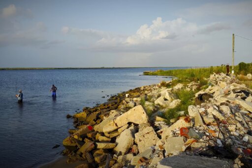
Fishing boat deckhand Jared Lemoine tosses an undersize fish back into Lake Borgne. Behind him lies a thin strip of land restored through the Lake Borgne Marsh Creation Project as a defense against erosion.
Despite everything, Shell Beach is not a desolate place: Isleño descendants still drive up the road to fish and shrimp the waters of Lake Borgne every day. The area has also become a robust location for recreational fishing camps, making it an important part of the region’s economy.
Over the past three decades, the state of Louisiana has been working to rebuild the desperately needed shoreline and develop new lines of defense against future storms. Near Shell Beach, the CPRA recently used dredging to complete the Lake Borgne Marsh Creation Project, Louisiana’s largest-ever marsh creation effort.
This project was one of six initiatives in the state selected through the Natural Resources Damage Assessment (NRDA) to restore ecosystems and industries, including fisheries, damaged by the 2010 Deepwater Horizon Oil Spill. The $110 million project used 15 million cubic yards of dredged sediment from Lake Borgne to create seven containment dikes—each surrounded by 4 ½-foot walls—around areas of open water and marsh along the shoreline.
When the project was finished in December 2025, it restored over 3,180 acres of wetlands along the lake’s southern shore. This restored marsh acts as both an inland structural buffer and a defense against storm damage, including to Shell Beach, while simultaneously restoring thousands of acres of functional marsh and vital nursery grounds for speckled trout, redfish, blue crabs, shrimp, and oysters.
But for the Isleño descendants who have shaped their lives around the region’s complex waterways, the project is not a sure bet. “It is good for protecting homes from storms, but as for growing oysters, it’s not going to do anything,” says Brad Robin. “The salinity levels and the tides will need to change for that. If we can rebuild the barrier islands, the ones our ancestors used to walk on, they will slow the saltwater coming in and return the estuary back to the state it was in when I was a little kid.”
The Lake Borgne Marsh Creation project was only completed three months ago, and locals cannot yet determine exactly how it will benefit the region’s estuaries.
“I still have a lot of hope,” says Robin. “Our past best growing areas could be our best growing areas again. I can’t give up that hope. It keeps me going.”

This sign sits at the entrance to Shell Beach, signaling a way of life that fishing families are determined to preserve for the next generation.

Locals gather on the Shell Beach docks at day’s end, where Isleño fishers have always unloaded their haul.

In a nearby pavilion across from the docks, a weekly Saturday concert brings the community together—a modern echo of the traditional Saturday nights when Isleño families gathered to cook and sing décimas, a ten-line stanza common in Spanish poetry.

A shrimp boat returns home to the harbor in Shell Beach. Time will tell whether the newly restored 3,180 acres of wetlands will replenish the lake’s oysters and other marine populations, now that the Lake Borgne Marsh Creation Project has been completed.
The post As Louisiana’s Wetlands Erode, A Fishing Culture Fights to Survive appeared first on Civil Eats.
From Civil Eats via This RSS Feed.