

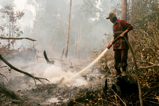
JAKARTA — Satellite imagery recorded more than 5,000 fire hotspots on peatlands across Indonesia in January, despite the fact that much of the country remains firmly in the grip of the rainy season. Independent watchdog Pantau Gambut identified 5,490 hotspots within peatlands, perennially waterlogged ecosystems that store massive amounts of carbon dioxide. Official monitoring also recorded an increase in fire hotspots, though using a different reporting method. Based on NASA Terra/Aqua satellite data, the Ministry of Forestry reported 110 hotspots nationwide in January 2026, up from 29 in January 2025 and 18 in December 2025. The two figures aren’t directly comparable, as they rely on different spatial filters and detection criteria. Pantau Gambut said the rise it recorded is concerning because it’s occurring during the wet season, which has been so intense this time around that it led to massive flooding in Sumatra in late 2025. The spike suggests fire risk in peat landscapes is no longer confined to the traditional dry season, but increasingly driven by degraded hydrology and land-use pressures, said Pantau Gambut campaigner Putra Saptian. Peat soil, which can be several meters deep, is made up of dead vegetation that, thanks to the waterlogged conditions, is only partially decomposed. In peat-rich areas across Sumatra and Borneo, logging and plantation companies have typically dug canals to drain the peat soil in preparation for cultivation, leaving behind vast swaths of highly flammable organic matter. Pantau Gambut recorded 1,824 hotspots inside the concessions of such companies in January, or a…This article was originally published on Mongabay
From Conservation news via This RSS Feed.