

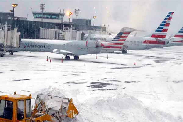
More than 7,000 flights were canceled and an additional 1,300 suspended across the United States this weekend as a severe winter storm brought heavy snow and blizzard conditions, disrupting holiday travel for millions, according to reports from the National Weather Service.
A powerful winter storm severely impacted air transportation across the United States this weekend, prompting widespread cancellations and suspensions.
By Saturday afternoon, snow accumulation reached 28 centimeters (11 inches) in parts of the New York and New Jersey metropolitan areas, significantly affecting one of the nation’s busiest travel hubs.
RELATED: Earthquake Shakes Lima and Northern Peruvian Cities
Over 7,000 flights nationwide were canceled, and another 1,300 faced suspensions, leaving countless travelers stranded during the critical holiday season. The escalating winter phenomenon progressively intensified throughout the day, exacerbating the operational challenges for airlines and airports.
Disruptive Snowfall Blankets Key Regions
On Saturday morning, New York City recorded approximately 10 centimeters (four inches) of snow, a figure initially below expectations. However, the snowfall intensified considerably by the afternoon. Beyond New York and New Jersey, Long Island also experienced significant accumulation, with reports indicating between 17.7 and 19 centimeters (approximately 7 to 7.5 inches) of snow.
These conditions made ground travel hazardous and directly contributed to the extensive air traffic delays and cancellations. The National Weather Service (NWS) issued a stark warning regarding the storm’s continued trajectory.
A powerful winter storm will affect the Upper Midwest, Great Lakes, and Northeast Sunday through Tuesday with heavy snow, blowing snow, and hazardous icing. See our latest Key Messages for more information and find your local forecast at https://t.co/pGx1JRZLBI. pic.twitter.com/gdrSXLtupV
— NWS Weather Prediction Center (@NWSWPC) December 27, 2025
The NWS stated, “This system is expected to be accompanied by numerous winter hazards starting tomorrow night, including blizzard conditions and snow accumulations of over 30 centimeters (a foot) in areas of the Upper Midwest and the Great Lakes.” This forecast indicates a prolonged period of severe weather, threatening further disruptions in other regions.
The Transportation Security Administration (TSA) had previously projected this holiday season to be one of the busiest on record, anticipating more than 44 million passengers traveling through airports; which combined with the extreme weather and the airport cancellations, creates a challenging scenario for authorities and millions of travelers trying to reach their destinations for the festive period.
The current situation reflects a complex interplay between severe meteorological conditions and peak travel demand. Authorities remain on high alert, working to manage the crisis while passengers navigate the uncertainty caused by the unprecedented number of flight disruptions. The winter storm continues to pose significant challenges, highlighting the vulnerability of national infrastructure to extreme weather events.
From teleSUR English via This RSS Feed.