

Drop Site is a reader-funded, independent news outlet. Without your support, we can’t operate. Please consider making a 501©(3) tax-deductible donation today.
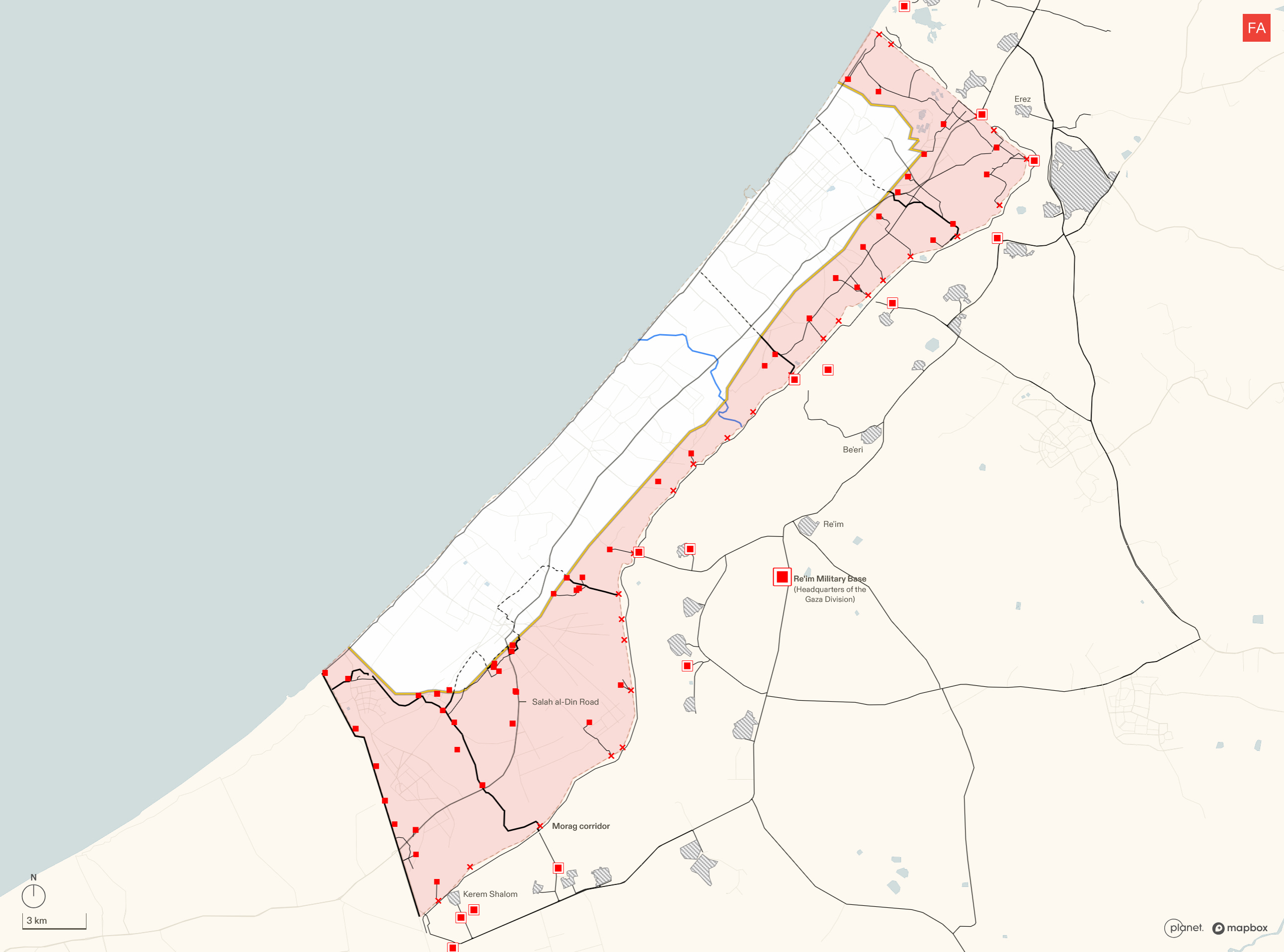
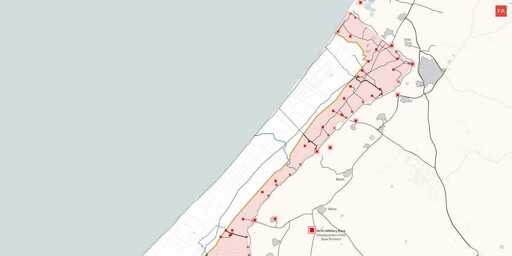
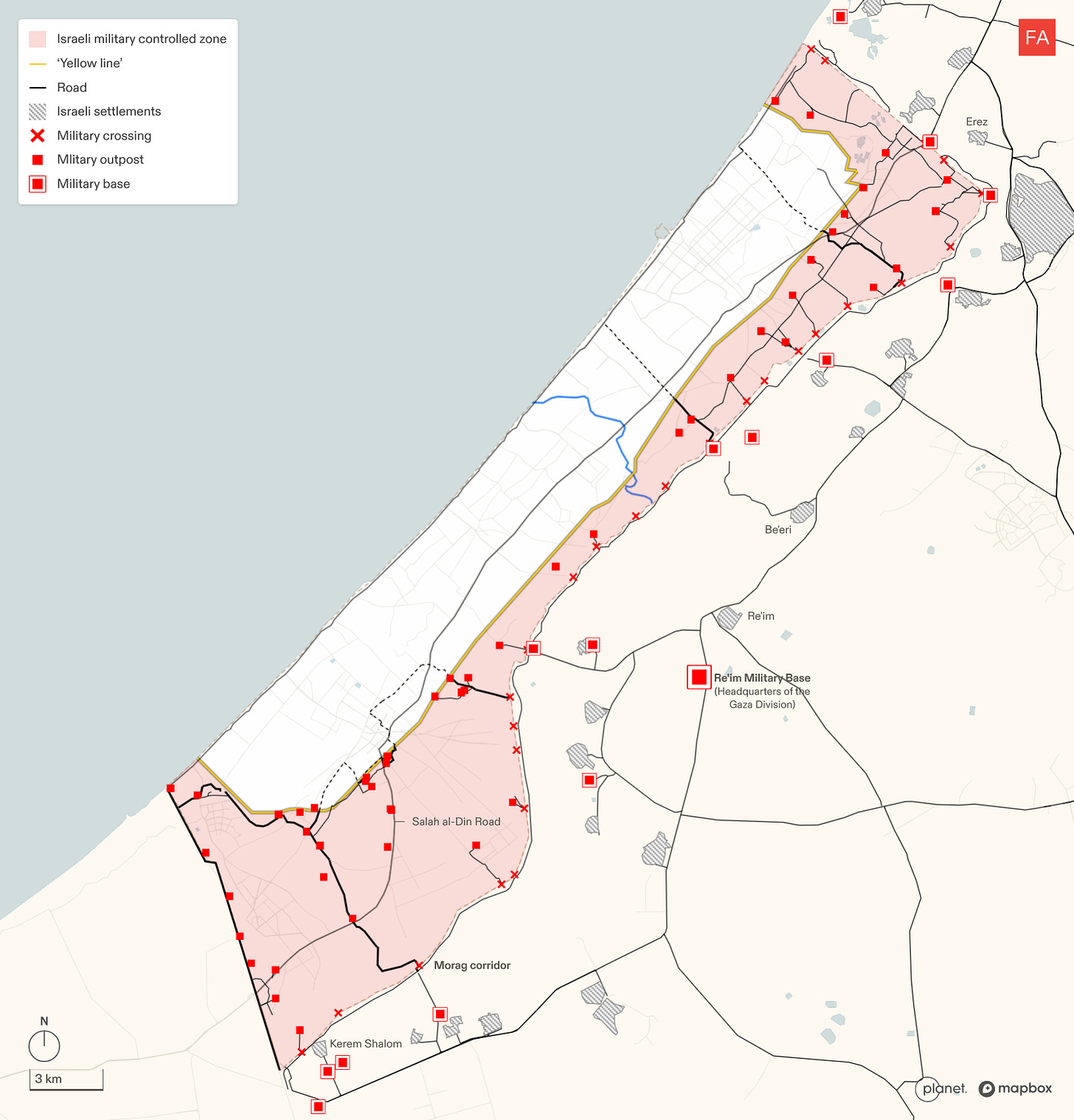
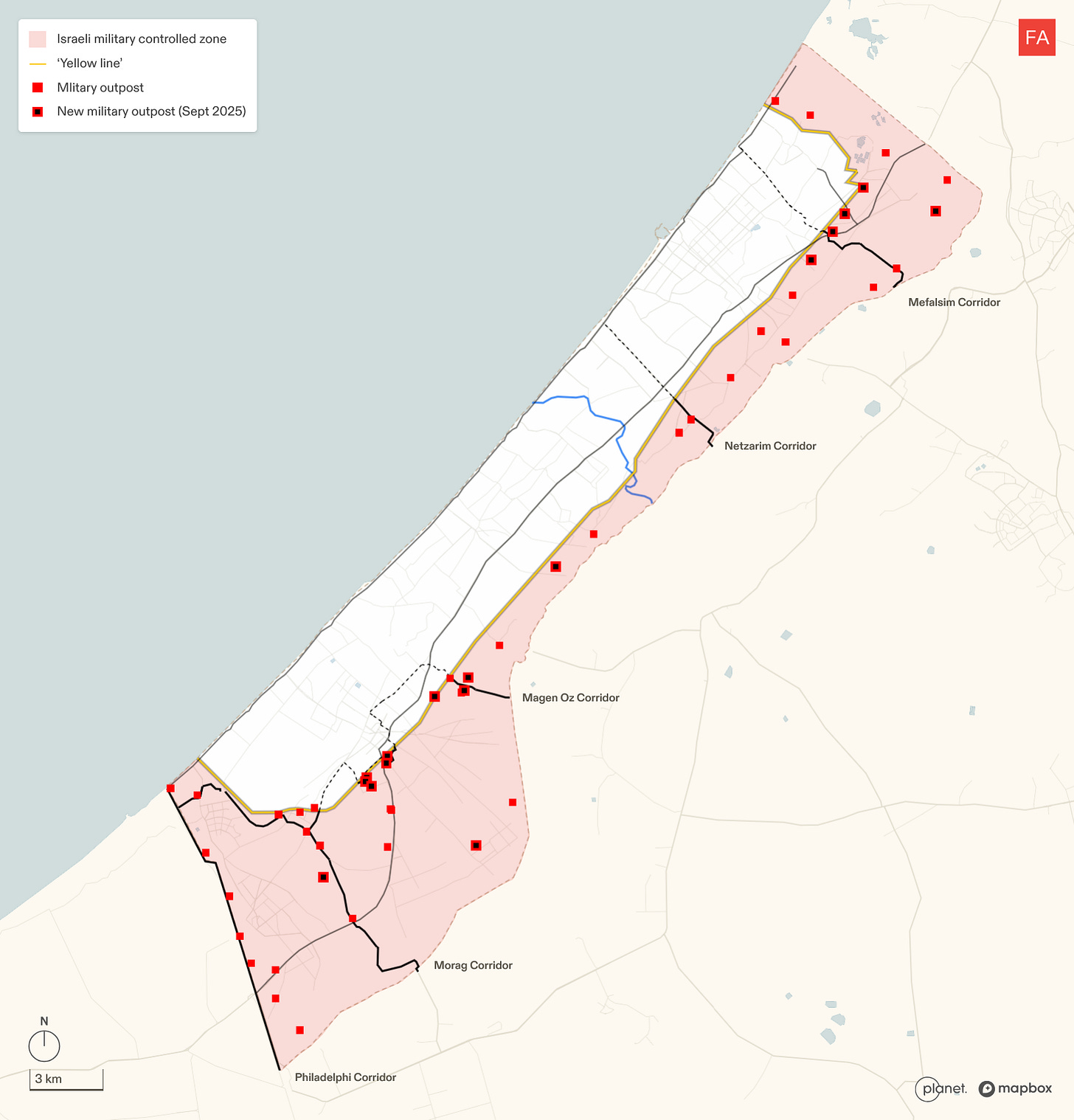
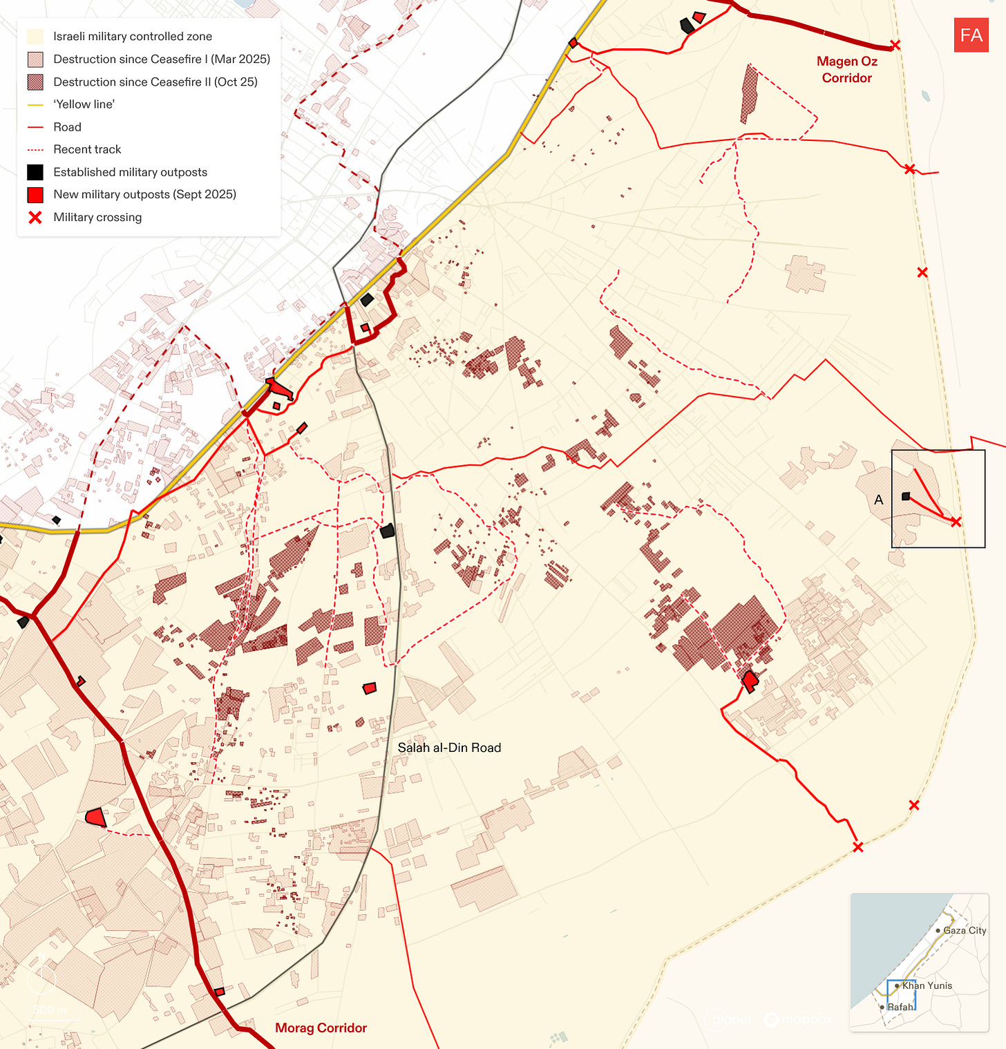
Israel is currently maintaining 48 military outposts east of the yellow line. Image by Forensic Architecture.
Since the so-called ceasefire came into effect in Gaza on October 10, Israel has been consolidating its control of over 50% of Gaza and—according to new research by Forensic Architecture—physically altering the geography of the land. Through a combination of the construction of military infrastructure alongside the destruction of existing buildings, Israel appears to be laying the groundwork to establish a permanent presence in the majority of the Gaza Strip.
Israel has constructed at least 13 new military outposts inside Gaza since the ceasefire—primarily located along the yellow line, in eastern Khan Younis, and near the border with Israel, according to analysis of satellite imagery by Forensic Architecture.
“Israel is doing what it always does, and what it historically has done best: establish ‘facts on the ground,’ incrementally rather than spectacularly, and make them permanent once those with influence to force it to reverse course either lose interest, decide that the cost of confronting Israel is not worth the price, or come out in open support of Israeli violations. Israel is in no rush and prepared to play the long game,” Mouin Rabbani, co-editor of Jadaliyya and a former UN official who worked as a senior analyst on Israel-Palestine for the International Crisis Group, told Drop Site after reviewing a summary of the Forensic Architecture findings.
The analysis also shows that, between October 10 and December 2, 2025, Israel has:
- Accelerated the growth and infrastructure development of 48 existing military outposts inside Gaza.
- Expanded a network of roads connecting military outposts inside Gaza to the Israeli road network, bases and settlements outside of Gaza.
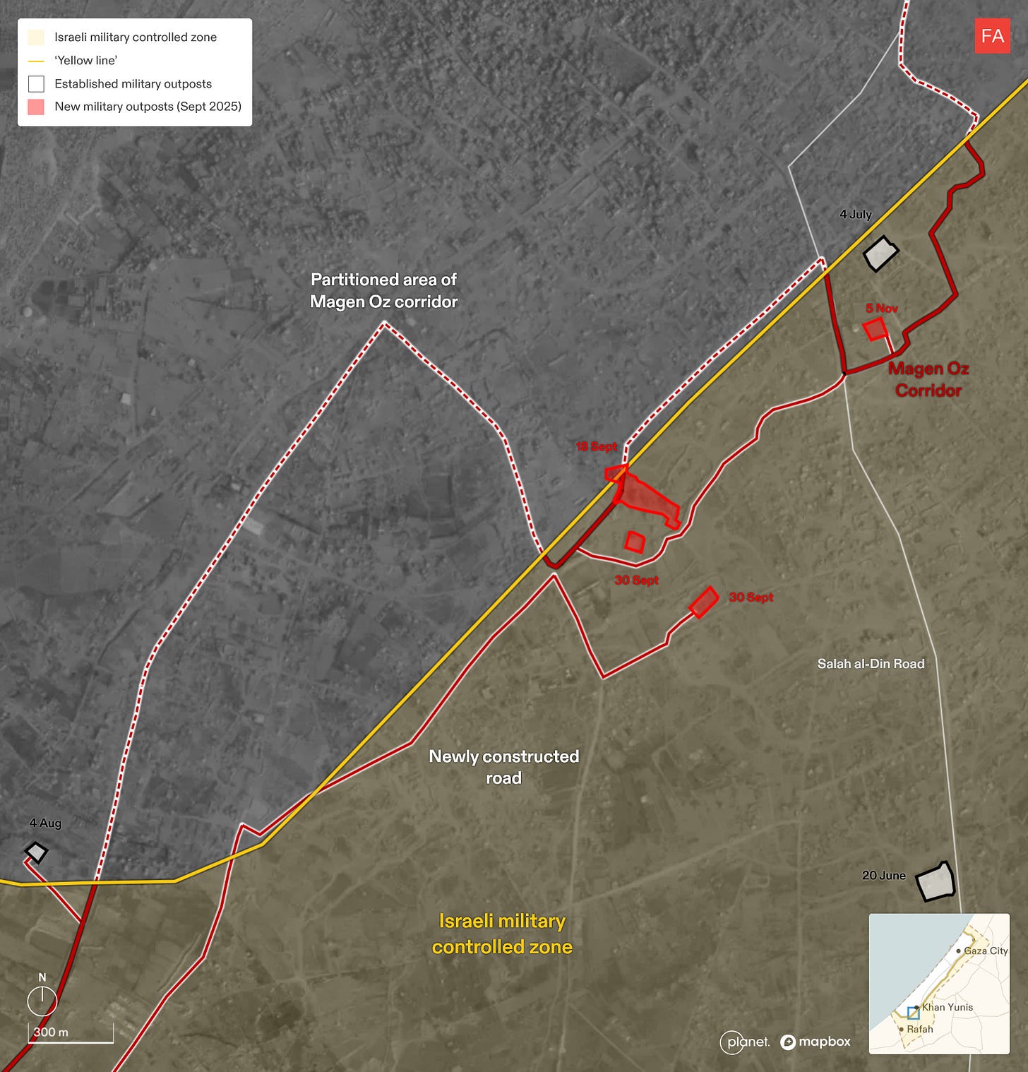
- Continued construction that began in September 2025 of a new road in Khan Younis, re-routing the Magen Oz corridor to run within Israel’s area of control.
- Engaged in the systematic demolition and destruction of Palestinian property, particularly in eastern Khan Younis, targeting areas which haven’t already been destroyed. New military outposts and roads have emerged across this area.
“Augmenting multiple Israeli statements about extending its borders with buffer zones to the north, east, and south, this is indisputably an Israeli campaign to partition the Gaza Strip and thereby promote its long-term objective of moving the Palestinian population elsewhere,” Rabbani said. “At the same time, Israeli success is not a foregone conclusion. If it was, the Palestinian population of the Gaza Strip would have been ethnically cleansed years if not decades ago.”
As part of the initial phase of the ceasefire agreement, the Israeli military partially withdrew to what became known as the “yellow line,” with over half of Gaza under continued Israeli control. The term comes from a map that was distributed in late September as part of President Donald Trump’s 20-point ceasefire plan that depicted a phased withdrawal of Israeli troops, to an initial yellow line, followed by another withdrawal, until an eventual pullback to a “buffer zone” running inside Gaza along the border with Israel.
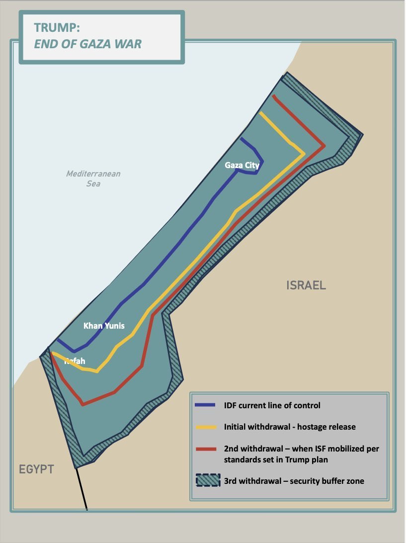
The original withdrawal map according to President Trump’s 20-point Gaza plan.
Trump then posted a new map showing the initial withdrawal line that left Israel in control of 58% of Gaza. After the ceasefire came into effect, an Israeli military spokesperson posted yet another map with the yellow line showing Israel in control of 53% of Gaza.
Since the ceasefire, Israel has seized more land by physically placing at least 27 yellow blocks (delineating its area of control) west of the yellow line marked in Israel’s own maps.
Point 16 of Trump’s 20-point plan explicitly states, “Israel will not occupy or annex Gaza. As the [International Stabilization Force (ISF)] establishes control and stability, the Israel Defense Forces (IDF) will withdraw based on standards, milestones, and timeframes linked to demilitarization.” It goes on to say, “Practically, the IDF will progressively hand over the Gaza territory it occupies to the ISF according to an agreement they will make with the transitional authority until they are withdrawn completely from Gaza, save for a security perimeter presence.”
While the “standards, milestones, and timeframes” around Israel’s withdrawal have been highly contentious, they are nevertheless the principal subject of ongoing negotiations. However, the analysis by Forensic Architecture clearly shows that Israel is consolidating its military presence on the ground east of the yellow line in a way that suggests no intention of a further withdrawal.
These findings come as the Trump administration is reportedly planning the construction of a number of residential compounds, dubbed “Alternative Safe Communities,” in areas east of the yellow line to provide housing to tens of thousands of Palestinians, with no construction allowed on the west side, that appear to be part of a plan to entrench the partition of Gaza and allow for permanent Israeli control over more than half of the enclave.
The Full Forensic Architecture Analysis
Israel’s network of military infrastructure
Within Gaza, Israel is currently maintaining 48 military outposts east of the yellow line. The outposts are connected to a network of roads which have been created, expanded or appropriated by the Israeli military. In turn, these link to Israeli bases, roads, and settlements outside of Gaza.
New Israeli military outposts
Since the ceasefire came into effect, Forensic Architecture observed three changes to Israeli military outposts east of the ‘yellow line’:
-
An increase in the number of outposts in locations strategic for occupation.
-
The expansion of outposts.
-
The development of outpost infrastructure.
Forensic Architecture documented 13 new outposts since the ceasefire. They are primarily located along the ‘yellow line’, in east Khan Younis, and near Gaza’s border.
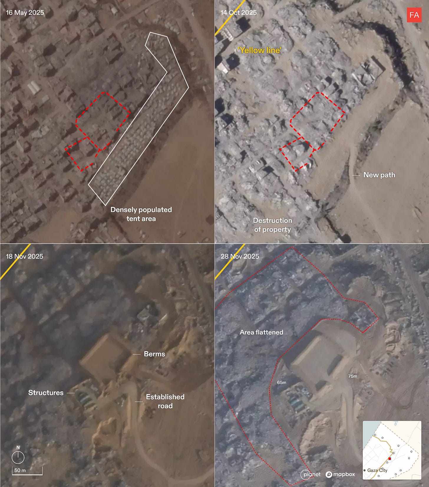
Case study: New military outpost in Jabaliya
At a new outpost in Jabaliya, a densely populated tent area was dismantled, and Israel demolished the surrounding buildings. In their place, Israel carved a road, built berms, and constructed buildings on the outpost. The largest berms measure 75 by 65 meters.
The outpost was constructed on high ground, and is visible on 26 November in a ground-level photograph taken from the west side of the ‘yellow line’, where Palestinians have been forcibly displaced to. The two areas are separated by a strip of destruction. From this vantage point, you can see the berms making up the outpost, with lights atop them, and the vehicles likely used to construct the outpost.
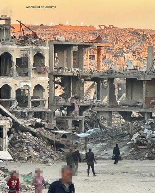
Photograph taken on 26 November 2025 in Jabaliya, west of the ‘yellow line’, looking towards an Israeli military outpost east of the 'yellow line. Source: @mahmoud__abusalama
Israel is rerouting existing military infrastructure to fall within its area of control
In mid-July 2025, the Israeli military announced the completion of the Magen Oz corridor, a 15-kilometer military road separating the city of Khan Younis into its eastern and western parts. Since September, Israel has been constructing a new road in Khan Younis, re-routing the Magen Oz corridor to run within its area of control.
Destruction in east Khan Younis
Military expansion is occurring alongside continued destruction east of the ‘yellow line’.
The largest body of land under Israel’s control is in the south of Gaza, and includes Rafah and eastern Khan Younis, which remains densely packed with private property. Here, since the ceasefire, Israel has been destroying buildings not previously destroyed, and constructed new military outposts and roads across the area.
Nearby, demolition vehicles (A) are visible on the border.
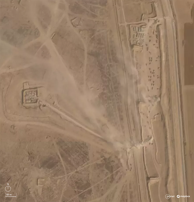
Military outpost in Khan Younis, on the border of Gaza, connected by road to a military crossing in which demolition and military vehicles are visible. 5 November 2025. Source: Planet Labs LBC.
For more detail, including additional maps and data, visit gaza.forensic-architecture.org/database or forensic-architecture.org/location/palestine
From Drop Site News via This RSS Feed.